
U.S. Department of State

U.S. Department of State (1789 - present) is the main foreign affairs body of the executive branch of the United States government. It has produced thousands of maps since the start of the 20th century dealing with U.S. geography, the geography of foreign countries, and the location of embassies and consulates.
Cheerful Cold War propaganda.
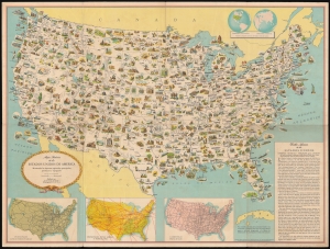
Mapa pictórico de los Estados Unidos de América: mostrando las riquezas regionales principales, productos y topografía.
$700.00
Acquire
- Digital Map Information
- Suitable for large format printing
- File Size: 118.41 MB
- File Type: ZIP / TIFF
- ICC color profile embedded
- Delivered instantly via download link
This is a c. 1952 Spanish language pictorial map of the continental United States published by the U.S. Department of State and distributed by the U.S. Information Agency (U.S.I.A.). Versions of this map were produced in many languages for international publication. Its innocuous presentation belies its role in the United States' worldwide propaganda campaign during the Cold War. (more details)