1950s Spanish-Language Pictorial Propaganda Map of the United States
UnitedStates-usia-1950$750.00


Title
Mapa pictórico de los Estados Unidos de América: mostrando las riquezas regionales principales, productos y topografía.
1950 (undated) 23.5 x 31.5 in (59.69 x 80.01 cm) 1 : 6250000
1950 (undated) 23.5 x 31.5 in (59.69 x 80.01 cm) 1 : 6250000
Description
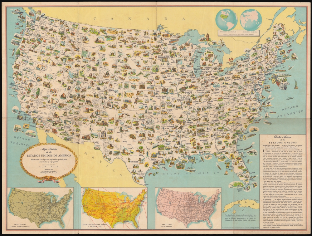
This is a c. 1952 Spanish language pictorial map of the continental United States published by the U.S. Department of State and distributed by the U.S. Information Agency (U.S.I.A.). Versions of this map were produced in many languages for international publication. Its innocuous presentation belies its role in the United States' worldwide propaganda campaign during the Cold War.
Three inset maps on the lower-left detail the principal rail, air, and road routes. At top-right are insets of the eastern and western hemispheres showing the relative position of the U.S. on the globe. At bottom-right is a text box detailing geographical, economic, and demographic information.
A Closer Look
The map is abundantly illustrated with resources, historic sites, and landmarks, including birthplaces of famous politicians and cultural figures. People at leisure activities - hunting, skiing, bobsledding, waterskiing, and frolicking on the beach - appear amongst laborers. Many of the illustrations of the western U.S. emphasize the mythology of the 'Old West,' complete with explorers, pioneer wagons, bison, cowboys, and Native Americans. (In an era in which young American boys frequently sported coonskin caps and cowboy costumes, this is perhaps to be understood.) Universities are prominently noted. It does not take long, however, to note the many references to America's military might: many of the ships shown at sea are warships; there is a similar preponderance of warplanes. Army training sites, aircraft factories, and munitions factories appear as well.Three inset maps on the lower-left detail the principal rail, air, and road routes. At top-right are insets of the eastern and western hemispheres showing the relative position of the U.S. on the globe. At bottom-right is a text box detailing geographical, economic, and demographic information.
Updated for the Cold War
This is not the first version of this map. An earlier version, published in the 1940s can be found. It is easily distinguishable from the United States population listed in the lower-right text box (138 million, as opposed to the 155 million shown here.) Close comparison of the two maps shows more changes, however. Off the coast of San Diego, a battleship has been replaced with an aircraft carrier and south of Pensacola, a propeller plane has been replaced with a jet fighter. Such reference to American might is selective: neither Strategic Air Command nor Los Alamos make any appearance here.Presenting the United States to the World
This map was published in many languages. This one is in Spanish, but we are aware of examples in English, Japanese, Russian, Chinese, Arabic, Farsi, German, and French, and more may exist. These were intended for broad distribution, as Spanish text at bottom states plainly:For distribution outside the United States and its territories and possessions, this map is available free of charge upon request from the nearest United States information office.The map was an explicit part of The United States' Cold War efforts to emphasize America's economic prosperity and military strength vis-a-vis the Soviet Union. We are aware of examples of this map having surfaced not only in Spain, but also in Cuba.
Publication History and Census
This map was printed by the General Drafting Company in New York on behalf of the U.S. State Department, to be distributed abroad by the United States Information Service (the name of U.S.I.A. abroad at this time). The map is undated, but as Alaska and Hawaii are referred to as territories of the U.S. rather than states, it must have been produced before they attained statehood in 1959. The population noted here, 155 million, falls between the numbers given in the 1951 and 1952 Census data. The changes noted above in the map's illustrations can also be observed in a Japanese edition tentatively dated 1953, so 1952 seems a reasonable estimate. The c. 1945 edition of this map is relatively ubiquitous in library collections, but this 1950s version is cataloged only by the Biblioteca Nacional de Espana and the University of Chicago (with a spurious date).CartographerS
U.S. Department of State (1789 - present) is the main foreign affairs body of the executive branch of the United States government. It has produced thousands of maps since the start of the 20th century dealing with U.S. geography, the geography of foreign countries, and the location of embassies and consulates. More by this mapmaker...
U.S. Information Agency (U.S.I.A.; 1953 – 1999), in its early years also known as United States Information Service (USIS) within the various embassies of the U.S. abroad, was a product of the Cold War dedicated to 'public diplomacy,' often but not exclusively anti-Communist propaganda in foreign languages targeted at the local population. It was preceded by the Office of the Coordinator of Information, created in 1941, which housed Voice of America (VOA) founded the following year. USAI was part of a massive information war effort to counter Communist and anti-American propaganda, especially in the Third World. The agency also produced information for the domestic audience, trumpeting the good work being done by U.S. entities and interests abroad. It also conducted public opinion polls throughout the world and produced twice-daily reports on foreign media for delivery to the President. Often collaborating with the State Department and Voice of America, USIA was instructed not to be overly transparent but to use subtle methods and messages to develop a positive image of the U.S. abroad. The agency was dissolved and placed within the State Department in 1999 as the office of Public Diplomacy and Public Affairs. Learn More...
General Drafting Corporation (1909 - 1992) was one of the 'Big Three' publishers of road maps between 1930 and 1970, along with H. M. Gousha and Rand McNally. Founded in 1909, Otto G. Lindberg, an immigrant from Finland and the company's founder, began his business with a borrowed drafting board and a $500 loan from his father. At the time only twenty-three years old, Lindberg advertised his business as 'any and all general drafting' and was based out of 170 Broadway in New York City. Only two years later, in 1911, the firm secured its first contract from the American Automobile Association to make 'road maps'. Lindberg incorporated his business in 1914 and became its first Chairman of the Board, a position he held until his death in 1968. Lindberg persuaded Standard Oil of New Jersey to let him draw the 'best' road map of the state that they had ever seen, and Standard Oil would distribute it for free. Sufficiently impressed with the finished product, Standard contracted General Drafting to make all their road maps - a relationship that lasted another six decades. This relationship allowed General Drafting to work exclusively for Standard Oil, but when oil companies stopped providing free maps, General Drafting was in a bind. The company tried to expand into the retail map market, and it of course continued creating maps for Exxon (the new name for Standard Oil) to sell, but its returns continued to decline. The firm was purchased in 1992 by Langenscheidt and subsequently absorbed into the American Map Company. General Drafting's state maps became this company's 'Travelvision' lineup. Learn More...
Condition
Very good. Some wear at junctures of folds, else excellent.
References
OCLC 971811460.