
Barbot, Jean

Jean Barbot (May 25, 1655 - December 27, 1712) was a French commercial agent on slave ships working for the Compagnie du Sénégal. Between 1678 and 1682 he made two voyages to the Guinea Coast; on the strength of these excursions he began to write an account based on his own journals as well as previously printed sources. He was made a refugee by French persecution of the Huguenots, fleeing to England in 1685. The interruption delayed completion of his work until 1688, at which point he discovered that so voluminous a French text could find no publisher in his new country. At his death in 1712 he was still revising and expanding an English edition of his work, which would not find a publisher until 1732. Barbot's 'A description of the coasts of north and south-Guinea, and of Ethiopia inferior, vulgarly Angola' provided a detailed description of what were commonly known as the 'Slave Coasts' and the Atlantic slave trade itself. Barbot's work was for centuries considered authoritative, although recent scholarship has revealed that a significant amount of his work relied on an amalgam of earlier writers, in particular Olfert Dapper (1639-1689).
Key Port in the Atlantic Slave Trade; also, Mermaids, err umm.. Manatees.
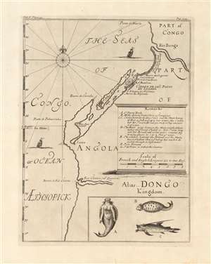
[Part of Congo / Part of Angola Alias Dongo Kingdom]
$500.00
Acquire
- Digital Map Information
- Suitable for large format printing
- Full resolution TIFF file
- ICC color profile embedded
- Delivered instantly via download link
This is a 1732 map of the coast of Angola, printed by Awnsham and John Churchill to accompany Jean Barbot's posthumously-published A description of the coasts of north and south-Guinea, and of Ethiopia inferior, vulgarly Angola. The map covers the Angolan coast from the Bengo River to the Cuanza river, but is in many respects a chart, only focusing on coastal detail. Its primary focus is on Luanda, its several navigational threats, and its fortifications; with particular detail regarding coastlines suitable for landing, the location of fresh water, and the vicinity of the Portuguese custom house. The map is centered on the island and fortress of Luanda, which is now the capital of Angola. Founded by the Portuguese in 1576, it is one of the oldest colonial cities in Africa: the center of the slave trade to Brazil before its abolition. Barbot's account was a description of the Atlantic Slave Trade, and this map presents details needed for ships to land, and take on their human cargo. (more details)
A Guide to the Guinea Coast.
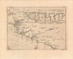
Part of the Kingdom of Melly, Part of Guinea, Bay of Sierra Liona.
$350.00
Acquire
- Digital Map Information
- Suitable for large format printing
- DPI: 600
- File Size: 28.79 MB
- File Type: ZIP / TIFF
- ICC color profile embedded
- Delivered instantly via download link
A very fine example of Johannes Kip's 1746 map and chart of the West African Coast from the Îles de Los in Guinea to the Cestos River in Liberia. This region attracted significant and increasing attention from Europeans in the early 18th century, as it became central to the transatlantic slave trade. (more details)