1746 Kip Map and Chart of the Guinea Coast, Sierra Leone, West Africa
Guinea-kip-1746$350.00

Title
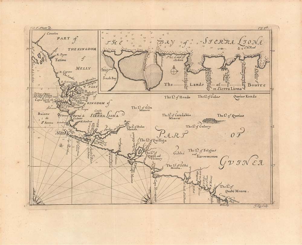
Part of the Kingdom of Melly, Part of Guinea, Bay of Sierra Liona.
1746 (undated) 9.5 x 13.25 in (24.13 x 33.655 cm) 1 : 1700000
1746 (undated) 9.5 x 13.25 in (24.13 x 33.655 cm) 1 : 1700000
Description
A very fine example of Johannes Kip's 1746 map and chart of the West African Coast from the Îles de Los in Guinea to the Cestos River in Liberia. This region attracted significant and increasing attention from Europeans in the early 18th century, as it became central to the transatlantic slave trade.
Like other maps of the 'Guinea Coast' from the 18th century, this combines a map of terrestrial features with a nautical chart, highlighting the limited knowledge of the interior among Europeans. Instead, islands, capes, and coastal features are meticulously documented, while soundings and coastal hazards are indicated. That being said, a distinctive characteristic of this map is the listing of indigenous groups in the interior regions of what is now Sierra Leone and Liberia.
The future site of Freetown, established in the 1790s, is located on the peninsula marked 'Land of Bourre'. Freetown Harbor, the largest and one of the best natural harbors in all of Africa, is to the left in the inset map, where it is noted 'Here is good fishing'. The inset also provides critical information about other locations along the southern bank of the Sierra Leone River, such as where fresh water and oysters could be found.
The Sierra Leone and Sherbro Rivers were the main sites of trade with Europeans, which included various goods but was increasingly dominated by the slave trade by the 18th century. The English had created a monopoly (the Royal African Company) to manage trade with this part of Africa, but it was supplanted in the early 18th century, creating a free-for-all among private traders that only increased the scale and brutality of the slave trade.
A Closer Look
Coverage extends from the Loos Islands or Îles de Los near today's Conakry in Guinea to the Cestos River in the middle of Liberia's coast, taking in the crucial Sierra Leone and Sherbro Rivers.Like other maps of the 'Guinea Coast' from the 18th century, this combines a map of terrestrial features with a nautical chart, highlighting the limited knowledge of the interior among Europeans. Instead, islands, capes, and coastal features are meticulously documented, while soundings and coastal hazards are indicated. That being said, a distinctive characteristic of this map is the listing of indigenous groups in the interior regions of what is now Sierra Leone and Liberia.
The future site of Freetown, established in the 1790s, is located on the peninsula marked 'Land of Bourre'. Freetown Harbor, the largest and one of the best natural harbors in all of Africa, is to the left in the inset map, where it is noted 'Here is good fishing'. The inset also provides critical information about other locations along the southern bank of the Sierra Leone River, such as where fresh water and oysters could be found.
The Transatlantic Slave Trade
These coasts were first visited by Europeans when the Portuguese reached the area in the 15th century, after which they returned regularly to trade. In the following centuries, and especially in the late 17th and early 18th century, European powers competed to control coastal forts and trading posts, which changed hands frequently. Piracy became rampant as privateers of various nations seized or interrupted the trade of their rivals.The Sierra Leone and Sherbro Rivers were the main sites of trade with Europeans, which included various goods but was increasingly dominated by the slave trade by the 18th century. The English had created a monopoly (the Royal African Company) to manage trade with this part of Africa, but it was supplanted in the early 18th century, creating a free-for-all among private traders that only increased the scale and brutality of the slave trade.
Publication History and Census
This map was engraved by Johannes Kip, based on the descriptions and drawings of the French Huguenot slave trader Jean Barbot, in his A description of the coasts of North and South Guinea … (published in 1732, after Barbot's death). It appeared in Volume 5 of Awnsham and John Churchill's A Collection of Voyages and Travels, published in 1746. It is not independently cataloged in the OCLC, while A Collection of Voyages and Travels is well-represented in the collections of major research universities.CartographerS
Johannes "Jan" Kip (1652 or 53 - 1722) was a Dutch draftsman, engraver and print dealer. Together with Leonard Knyff, he made a speciality of engraved views of English country houses and towns. Kip learned his trade under Stopendaal from 1668 to 1670. His own work began to appear in 1672. After producing works for the court of William ofOrange in Amsterdam, Kip relocated to London (following King William III and Queen Mary II in the 'Glorious Revolution' of 1688.) He then travelled around England documenting notable estates. to found a successful printselling business. He worked as an illustrator for other London publishers as well as his own. He is perhaps best known for the folio illustrations he produced for the 1708 Britannia Illustrata, 1708 and 65 plates he engraved for Sir Robert Atkyns' 1712 The Ancient and Present State of Glostershire, and for Le Nouveau Théâtre de la Grande Bretagne, 1715. More by this mapmaker...
Jean Barbot (May 25, 1655 - December 27, 1712) was a French commercial agent on slave ships working for the Compagnie du Sénégal. Between 1678 and 1682 he made two voyages to the Guinea Coast; on the strength of these excursions he began to write an account based on his own journals as well as previously printed sources. He was made a refugee by French persecution of the Huguenots, fleeing to England in 1685. The interruption delayed completion of his work until 1688, at which point he discovered that so voluminous a French text could find no publisher in his new country. At his death in 1712 he was still revising and expanding an English edition of his work, which would not find a publisher until 1732. Barbot's 'A description of the coasts of north and south-Guinea, and of Ethiopia inferior, vulgarly Angola' provided a detailed description of what were commonly known as the 'Slave Coasts' and the Atlantic slave trade itself. Barbot's work was for centuries considered authoritative, although recent scholarship has revealed that a significant amount of his work relied on an amalgam of earlier writers, in particular Olfert Dapper (1639-1689). Learn More...
Awnsham Churchill (1658–1728) was an English bookseller; he was also a radical Whig politician who sat in the House of Commons from 1705 to 1710. He was the son of William Churchill and Elizabeth Awnsham, and brother of members of Parliament Joshua and William Churchill. Apprenticed to George Sawbridge, Awnsham became a Freeman of the Stationers' Company in 1681. He, with another brother, John, entered business as booksellers and stationers. They were politically engaged, and took part in opposition to James II of England, going so far as to consort with those supporting Monmouth's Rebellion in Amsterdam. Awnsham was arrested in 1687 for printing letters promoting William of Orange's policies of religious toleration. With the rise of William III, however, Churchill would flourish: he became stationer to the King, and a leading bookseller. He became a Whig Member of Parliament for Dorchester in 1705 and 1708. His radicalism led to his defeat in 1710, and a failed 1713 election attempt spelled the end of his political ambitions. Awnsham was friendly with John Locke, served as his publisher, and managed Locke's money and business - becoming his trustee after his death. Learn More...
Source
Churchill, A. and J., A Collection of Voyages and Travels, Vol V, (London) 1746.
Condition
Very good. Fold line faintly visible. Minor imperfections in the margins.