
Block, Adriaen

Adriaen Block (c. 1567 – 1627) was a Dutch private trader, privateer, and ship's captain best known for exploring the coastal and river valley areas between present-day New Jersey and Massachusetts between 1611 to 1614. He is associated with possibly having named Block Island, Rhode Island, and establishing early trade with the Native Americans. The 1614 map of his last voyage provided the basis for Willem Blaeu's Nova Belgica et Anglia Nova, which would present many European readers with their first image of the mid-Atlantic region appear for the first time. The term 'New Netherland' appeared on the Block chart for the first time.
Though his childhood is obscure to us, by 1590 Block appears to have been active in the European shipping trade and by 1601, he had sailed as far as the Dutch East Indies. By 1604 he had been granted Letters of Marque from Dutch authorities to capture enemy ships, on which he seems to have made good at least once. Reports of Hudson's 1609 voyage to the Hudson Valley led Block to make three journeys to the same vicinity and its surrounds. He would be the first known European to sail through Hell Gate and explore the East River, and one of the first to explore Long Island Sound.
Though his childhood is obscure to us, by 1590 Block appears to have been active in the European shipping trade and by 1601, he had sailed as far as the Dutch East Indies. By 1604 he had been granted Letters of Marque from Dutch authorities to capture enemy ships, on which he seems to have made good at least once. Reports of Hudson's 1609 voyage to the Hudson Valley led Block to make three journeys to the same vicinity and its surrounds. He would be the first known European to sail through Hell Gate and explore the East River, and one of the first to explore Long Island Sound.
The first edition of one of the most distinctive maps of the Dutch Golden Age.
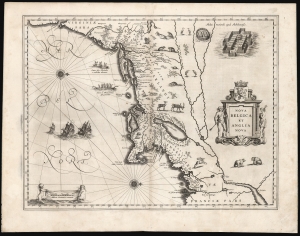
Nova Belgica Et Anglia Nova.
$5,000.00
Acquire
- Digital Map Information
- Suitable for large format printing
- Full resolution TIFF file
- ICC color profile embedded
- Delivered instantly via download link
This is the rare 1634 first atlas edition of Willem Blaeu's foundational map of the American Northeast, presenting the regions settled by the Dutch (New Netherlands) and the English (New England). Uniquely oriented to the west, Blaeu's map covers the American coast from Virginia, past New York and Long Island to Cape Cod, New England, and Quebec. The map is the first of the region to depict the fur-bearing and food animals of the region accurately, and it does so in profusion. Between this imagery and the fleet of trade ships heading towards the coast, the decorative elements vividly emphasize the region's resource wealth. (more details)