
Boisseau, Jean

Jean Boisseau (fl. c. 1631 – 1657) was a French cartographer, publisher and enlumineur (colorist) active in the middle of the 17th century. Boisseau produced a number of important maps and atlases, including his 1643 reduction of Champlain's map, entitled Description de la Nouvelle France, identified as the first to name all five of the Great Lakes. He also produced the famous Colonel's Plan of Paris, and an important atlas, Tresor des Cartes Geographiques, arguably the first French world atlas. He held the post of Enlumineur du Roy pour les cartes geographiques and his work as a colorist is evident in map maps of the period from Royal libraries.
The first map to illustrate and name all five of the Great Lakes.
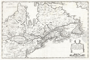
Description de la Nouvelle France, ou, sont remarquées les diverses habitations des françois, despuis la première descouverte jusques à present, receuillie et dressée sur diverses relations modernes.
$23,000.00
Acquire
- Digital Map Information
- Suitable for large format printing
- DPI: 300
- File Size: 8.1 MB
- File Type: ZIP / TIFF
- ICC color profile embedded
- Delivered instantly via download link
A rare separately published map considered the to be the first to illustrate all five of the Great Lakes. Drawn by Jean Boisseau, this map is cartographically derived from Samuel de Champlain's important map of 1632 with some important changes. The map covers from ... (more details)