
Churchill, Awnsham

Awnsham Churchill (1658–1728) was an English bookseller; he was also a radical Whig politician who sat in the House of Commons from 1705 to 1710. He was the son of William Churchill and Elizabeth Awnsham, and brother of members of Parliament Joshua and William Churchill. Apprenticed to George Sawbridge, Awnsham became a Freeman of the Stationers' Company in 1681. He, with another brother, John, entered business as booksellers and stationers. They were politically engaged, and took part in opposition to James II of England, going so far as to consort with those supporting Monmouth's Rebellion in Amsterdam. Awnsham was arrested in 1687 for printing letters promoting William of Orange's policies of religious toleration. With the rise of William III, however, Churchill would flourish: he became stationer to the King, and a leading bookseller. He became a Whig Member of Parliament for Dorchester in 1705 and 1708. His radicalism led to his defeat in 1710, and a failed 1713 election attempt spelled the end of his political ambitions. Awnsham was friendly with John Locke, served as his publisher, and managed Locke's money and business - becoming his trustee after his death.
Key Port in the Atlantic Slave Trade; also, Mermaids, err umm.. Manatees.
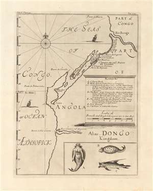
[Part of Congo / Part of Angola Alias Dongo Kingdom]
$500.00
Acquire
- Digital Map Information
- Suitable for large format printing
- Full resolution TIFF file
- ICC color profile embedded
- Delivered instantly via download link
This is a 1732 map of the coast of Angola, printed by Awnsham and John Churchill to accompany Jean Barbot's posthumously-published A description of the coasts of north and south-Guinea, and of Ethiopia inferior, vulgarly Angola. The map covers the Angolan coast from the Bengo River to the Cuanza river, but is in many respects a chart, only focusing on coastal detail. Its primary focus is on Luanda, its several navigational threats, and its fortifications; with particular detail regarding coastlines suitable for landing, the location of fresh water, and the vicinity of the Portuguese custom house. The map is centered on the island and fortress of Luanda, which is now the capital of Angola. Founded by the Portuguese in 1576, it is one of the oldest colonial cities in Africa: the center of the slave trade to Brazil before its abolition. Barbot's account was a description of the Atlantic Slave Trade, and this map presents details needed for ships to land, and take on their human cargo. (more details)
A Guide to the Guinea Coast.
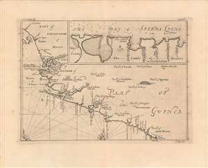
Part of the Kingdom of Melly, Part of Guinea, Bay of Sierra Liona.
$350.00
Acquire
- Digital Map Information
- Suitable for large format printing
- DPI: 600
- File Size: 28.79 MB
- File Type: ZIP / TIFF
- ICC color profile embedded
- Delivered instantly via download link
A very fine example of Johannes Kip's 1746 map and chart of the West African Coast from the Îles de Los in Guinea to the Cestos River in Liberia. This region attracted significant and increasing attention from Europeans in the early 18th century, as it became central to the transatlantic slave trade. (more details)