
De Leth, Hendrik

Hendrik de Leth (May 31, 1703 - June 17, 1766) was a Dutch print artist, etcher, engraver, mapmaker, draftsman, bookseller, art dealer, print publisher, art collector, and naturalist. He was the son of Andries de Leth (also an engraver and bookseller, 1662-1731) He trained under his father, and joined the bookseller's guild at the age of 25. The elder De Leth had taken over the Visscher mapmaking business after the death of Nicholas II, and, Hendrik de Leth in turn took over after the death of his father. De Leth would be better known perhaps for his prints than his maps, though he produced a geographical atlas and historical atlas in 1740.
Caught between the French and the Germans for over 100 years.
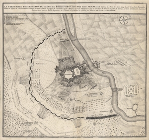
La Veritable Description du Siêge de Philipsbourg par les François.
$900.00
Acquire
- Digital Map Information
- Suitable for large format printing
- DPI: 600
- File Size: 45.71 MB
- File Type: ZIP / TIFF
- ICC color profile embedded
- Delivered instantly via download link
This is the 1734 Hendrik de Leth battle plan or map of the siege of Philippsburg in modern-day Baden-Württemberg, Germany. A fortified city along the Rhine, Philippsburg was contested between the French and Germans since 1644. (more details)