1734 Hendrik de Leth Battle Plan or Map of the Siege of Philippsburg, Germany
SiegePhilipsbourg-leth-1734$900.00

Title
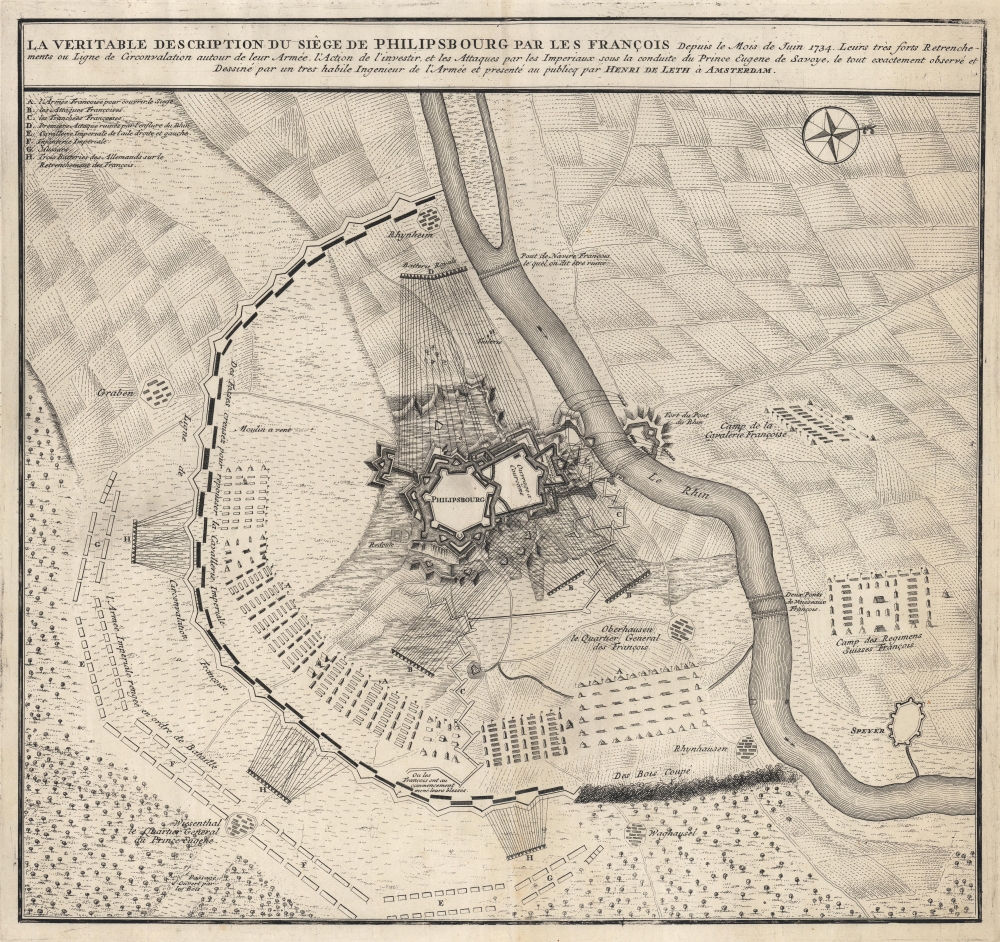
La Veritable Description du Siêge de Philipsbourg par les François.
1734 (undated) 18.25 x 19.25 in (46.355 x 48.895 cm) 1 : 38000
1734 (undated) 18.25 x 19.25 in (46.355 x 48.895 cm) 1 : 38000
Description
This is the 1734 Hendrik de Leth battle plan or map of the siege of Philippsburg in modern-day Baden-Württemberg, Germany. A fortified city along the Rhine, Philippsburg was contested between the French and Germans since 1644.
A Closer Look
Detailing Philippsburg's fortifications on both sides of the Rhine, letters identify French and German positions around with a key situated in the upper left. French cavalry and French Swiss regiments are marked by text, as are French entrenchments to rebuff the Imperial attack and relieve the siege. The French bridges across the Rhine are labeled as well (Deux Pont de Vaisseaux François).The Siege of Philippsburg
The Siege of Philippsburg (June 2 - July 18, 1734) occurred during the War of the Polish Succession (1733 - 1735) and was the second siege of the city in the previous fifty years. The siege lasts for over a month, with the French fighting off a relief effort led by Prince Eugene of Savoy. The French breached the first line of defense on July 17, reaching the citadel's ramparts, and the city surrendered the following day.The War of the Polish Succession
The War of the Polish Succession (October 10, 1733 - October 3, 1735) was a major European war ignited by the Polish Civil War over the succession of King Augustus II of Poland. France, Spain, and the Kingdom of Prussia fought to test the power of the Austrian Habsburgs, while Russia and Saxony fought to support the eventual successor. After two years of war, with most of the associated military campaigns fought outside of Poland, Augustus III ascended to the throne, with the support of the Habsburgs, Russia, and Saxony. Although fighting ended in 1735, the Treaty of Vienna that formally ended the war was not signed until 1738. Augustus III was formally recognized as king, and his rival, Stanisław Leszczyński, was awarded two fiefs within the Holy Roman Empire: the Duchy of Bar and the Duchy of Lorraine. The war resulted in several duchies and fiefdoms changing hands and, more importantly, it was disastrous for Polish independence. There would only be one more Polish king, Stanisław August Poniatowski (who was a Russian puppet) before Poland was divided amongst its neighbors in the First Partition of Poland.Publication History and Census
This map was created and published by Hendrick de Leth in 1734. We note four cataloged examples which are part of the collections at the Bibliothèque nationale de France, the Royal Collection Trust, the Bibliotheek Universiteit van Amsterdan, and the Newberry Library.Cartographer
Hendrik de Leth (May 31, 1703 - June 17, 1766) was a Dutch print artist, etcher, engraver, mapmaker, draftsman, bookseller, art dealer, print publisher, art collector, and naturalist. He was the son of Andries de Leth (also an engraver and bookseller, 1662-1731) He trained under his father, and joined the bookseller's guild at the age of 25. The elder De Leth had taken over the Visscher mapmaking business after the death of Nicholas II, and, Hendrik de Leth in turn took over after the death of his father. De Leth would be better known perhaps for his prints than his maps, though he produced a geographical atlas and historical atlas in 1740. More by this mapmaker...
Condition
Very good. Light wear along original centerfold. Closed margin tears professionally repaired on verso.
References
Bibliothèque nationale de France, département Cartes et plans, GE C-3428. Royal Collection Trust RCIN 727056. OCLC 71533863, 954483249.