
Dirección General de Correos y Telegrafos

The Dirección General de Correos y Telegrafos (1933 - 1942) was created in 1933 when President Abelardo L. Rodríguez issued a presidential order directing the postal service to take control of telegraph service in Mexico. It was disbanded nine years later when President Manuel Avila Camacho ordered that the postal and telegraph services be separated.
Traces mail routes in Jalisco that are delivered on foot, on horseback, by car, and by tram in a region famous for its tequila.
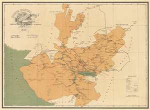
Carta Postal de la Republica Mexicana Estado de Jalisco.
$500.00
Acquire
- Digital Map Information
- Suitable for large format printing
- File Size: 28.55 MB
- File Type: ZIP / TIFF
- ICC color profile embedded
- Delivered instantly via download link
This is a 1934 General Directorate of Post and Telegraphs map of Jalisco, Mexico. Centered on the major city of Guadalajara, the map's coverage extends to all of Jalisco's unusual shape, from the Pacific to its borders with Guanajuato, Zacatecas, Durango, and Michoacán. Today Jalisco is best known outside of Mexico for the production of tequila, one of the great artisanal sprits. It also has a significant mezcal tradition. But this map is about the mail… (more details)
The Yucatan at the height of the Henequen boom!
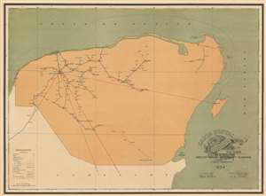
Carta Postal de la Republica Mexicana Estado de Yucatan.
$500.00
Acquire
- Digital Map Information
- Suitable for large format printing
- File Size: 26.77 MB
- File Type: ZIP / TIFF
- ICC color profile embedded
- Delivered instantly via download link
This is a 1934 General Directorate of Post and Telegraphs map of Yucatan, Mexico. The map comprises all of modern-day Yucatan as well as the adjacent modern state of Quintana Roo, including the resort cities of Playa del Carmen, Tulum, Cancun, and the resort islands of Cozumel and Isla Mujeres. The content of the map is nonetheless centered on the spiderweb of roads and tramlines extending outward from Merida - then the center of the henequen trade. Henequen, a type of agave indigenous to the Yucatan peninsula was, for nearly 100 years, the world's finest source of rope-making fiber, making Merida one of the wealthiest cities on Earth. Nonetheless, the emptiness of this map, particularly in the eastern parts, emphasizes the inhospitable nature of most of the peninsula. Around the time this map was issued, faced with competition from other fiber sources, changes in government, and inattention on the part of the hacienda owners, the henequen trade began its fast decline. But, this map is about the mail… (more details)