
Dudley, Robert

Sir Robert Dudley (August 7, 1573 - September 6, 1649) was an English explorer and cartographer, the publisher of the Dell’Arcano de Mare, one of the greatest nautical atlases of all time. He was the illegitimate son of Robert Dudley, 1st Earl of Leicester (a favorite of Queen Elizabeth I) and Douglas Sheffield, the widow of John Sheffield, 2nd Baron Sheffield. In 1594, Dudley led an expedition across the Atlantic, with the intent of harassing Spanish merchantmen. His expedition met with a series of misfortunes, but successfully returned to England the following year. In 1596, Dudley joined an expedition led by Robert Devereux, 2nd Earl of Essex, against Cadiz. He served as the commander of the Nonpareil, and was knighted for his conduct in the capture of Cadiz. In 1603, Dudley made an attempt to establish his legitimacy at court and gain several inheritances, after being (possibly erroneously) informed that his parents had been secretly married. No concrete proof of the marriage could be furnished, thus the judgement was handed down against him in May 1605. Dudley left England in July of the same year, with his lover and cousin Elizabeth Southwell, who was disguised as his page. They married in Lyon in 1606 having received a papal dispensation. The couple settled in Florence, where Dudley began using his father’s title, Earl of Leicester, and his uncle’s, Earl of Warwick. In Florence, Dudley designed and built warships for the arsenal at Livorno and became a naval advisor to Ferdinand I, Grand Duke of Tuscany. In 1607, James I revoked Dudley’s travel license once ordered that he return to provide for his deserted wife and family. Dudley refused, was subsequently labeled an outlaw, and his estate was confiscated. By far Dudley’s most important work was the Dell’Arcano del Mare (Secrets of the Sea). His most celebrated achievement, is the atlas of sea charts of the world which accompanied the work. This maritime atlas was the first nautical atlas of the entire world in print, the first made by an Englishman, the first to show prevailing winds and currents, and the first to use the Mercator projection throughout.
Earliest published sea chart focusing on the California coast!
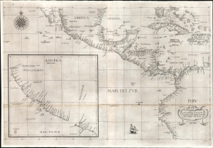
Carta prima generale d'America dell'India Occidentale e Mare del Zur.
$7,000.00
Acquire
- Digital Map Information
- Suitable for large format printing
- File Size: 26.19 MB
- File Type: ZIP / TIFF
- ICC color profile embedded
- Delivered instantly via download link
This is the 1646 first state of Robert Dudley's chart of the middle part of the Americas, illustrating the proximity of the Caribbean Sea and the Pacific Ocean and emphasizing the narrow parts of Central America dividing the two bodies of water. The chart features the western part of the Caribbean, but it is particularly noted for being the first printed sea chart to focus on the Pacific coast, including California. It is, along with Dudley's more narrowly focused charts, the first printed chart of the West Indies and South Florida to employ the Mercator Projection. An inset chart in the lower left focuses specifically on the coast of California, from Baja to Cap Mendocino. (more details)
The first English Printed Nautical Chart to the Indies.
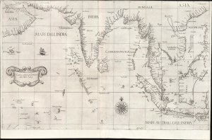
Carta prima Generale dell' Asia.
$25,000.00
Acquire
- Digital Map Information
- Suitable for large format printing
- File Size: 28.34 MB
- File Type: ZIP / TIFF
- ICC color profile embedded
- Delivered instantly via download link
This is a superb, first-state example of Robert Dudley's 1646 general nautical map of South Asia, from the Arabian Peninsula to the Philippines, including the coastlines of India, the Malay Peninsula, Cochinchina, and southern China. Countless islands of the Indian Ocean are charted, as are the western parts of the East Indies. It is the first printed chart of the route to the Spice Islands produced by an Englishman; it is the first to utilize the Mercator Projection, and the first to show prevailing winds, currents, and magnetic variation. The chart's portolan-like lines suggest its origin in the manuscript charts that informed it. Aesthetically, they distinguish this chart as one of the most elegant works dedicated to the region. It is a rarity on the market and a prize map for collectors. (more details)
First printed English Nautical Chart of New York and New England. / First use of the name 'Connecticut' in any form.
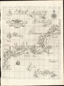
Carta particolare della nuova Belgia è parte della nuova Anglia La longitudiné Cominca da l'Isola di Pico d'Asores. D'America Carta II.
$40,000.00
Acquire
- Digital Map Information
- Suitable for large format printing
- File Size: 14.46 MB
- File Type: ZIP / TIFF
- ICC color profile embedded
- Delivered instantly via download link
This is a superb example of Robert Dudley's 1647 / 1661 nautical map of the coast of New York and New England - according to Burden, the 'first printed sea chart of New England and the New Netherlands.' Moreover, it is the first chart of New England to be produced by an Englishman. The chart's portolan-like lines and exquisite Florentine calligraphy distinguish it as one of the most beautiful works dedicated to the region. It is a rarity on the market, and a prize map for collectors of New York and New England. (more details)
Earliest Detailed Chart of the Cape Verde Islands, Senegal, and the lower Gambia River.
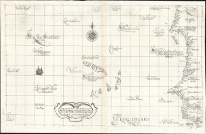
Carta particolare della Barberia Australe che comincia con il capo Matas è Finiscie con il C. Himilas con l'Isole di capo Verde.
$3,000.00
Acquire
- Digital Map Information
- Suitable for large format printing
- Full resolution TIFF file
- ICC color profile embedded
- Delivered instantly via download link
This is a superb example of Robert Dudley's rare 1647 nautical chart or map of the coast of Africa, focusing on the Cape Verde Islands and the mainland from the Western Sahara to the northern part of Guinea. It is both beautifully engraved and an important, early work. It is the earliest accurate printed chart of the Cabo Verde Islands and the coastlines of Senegal, The Gambia, and Guinea. (more details)