
1647 Robert Dudley Map of Senegal, Gambia and the Cape Verde Islands

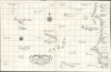

Carta particolare della Barberia Australe che comincia con il capo Matas è Finiscie con il C. Himilas con l'Isole di capo Verde.
Earliest Detailed Chart of the Cape Verde Islands, Senegal, and the lower Gambia River.
- Digital Map Information
- Suitable for large format printing
- Full resolution TIFF file
- ICC color profile embedded
- Delivered instantly via download link
Earliest Detailed Chart of the Cape Verde Islands, Senegal, and the lower Gambia River.
This is a superb example of Robert Dudley's rare 1647 nautical chart or map of the coast of Africa, focusing on the Cape Verde Islands and the mainland from the Western Sahara to the northern part of Guinea. It is both beautifully engraved and an important, early work. It is the earliest accurate printed chart of the Cabo Verde Islands and the coastlines of Senegal, The Gambia, and Guinea.A Closer Look
This north-oriented chart spans from the Western Sahara coast just short of the Tropic of Cancer to just south of the Bijagós Islands of Guinea-Bissau. Cap Blanco, the infamous Arguin Banks, Cape Verde, and the mouths of the Senegal and Gambia Rivers can all be seen. The Cape Verde Islands are positioned centrally on the chart.The area is presented on a Mercator projection. Dudley's Arcano del Mare is the first sea atlas to employ this complicated but useful method, which ensured that a straight line on the page would accurately represent a straight line on the surface of the globe. Therefore, the Arcano del Mare was the first assemblage of printed charts serviceable for navigation.
This usefulness to the navigator is also emphasized by the chart's inclusion of shoals - notably, the Arguin Bank. Although it is noted here as a fishing ground rather than a navigational threat. Dudley's charts were the first to include prevailing winds and compass variations, and this is no exception. Depth soundings appear in profusion along the mainland coasts; the few soundings among the Cape Verde Islands themselves are astonishingly - and largely accurately - deep.
Geology of the Cape Verde Islands
As is noted on the chart, the Cape Verde Islands lurch up from an extremely deep part of the ocean; this is due to the volcanic nature of the whole archipelago. The still-active Pico do Fogo is pictured on the island of Fogo (indeed, the entire island is made up of that stratovolcano).Dudley's Sources
Dudley was a well-informed mapmaker. He was keen to draw on new sources wherever he could glean them. He himself crossed the Atlantic, and his charts of Guiana and the West Indies may have benefited from his own observation. In many cases, his sources were English, particularly the manuscript works of the Thames School of chartmakers, whose masters are today known only by their names and their works. Several Thames school charts embracing this region have survived, enough to suggest that at least Dudley's treatment of the Cape Verde Islands is derived from a chart produced in that tradition. However, we have been unable to identify any surviving chart from any source that presents a map this focused on the region, and as detailed in its depth soundings and coastal information. Indeed, while these manuscripts are good candidates for Dudley's mapping of the Cape Verde Islands, the mainland is charted quite differently and in much sharper detail than any surviving chart of which we are aware.Some known narrative sources appear to be informing Dudley's chart. The 1594 account of Cape Verdan/Portuguese André Álvares de Almada (1555-1650), Tratado breve dos rios de Guiné do Cabo Verde dês do Rio Sanagá, was an authoritative work pertaining to the charted region. Some of the names of settlements on this chart appear to be drawn from that work. Also, during the first half of the seventeenth century, the English had been attempting to develop connections with the gold trade in West Africa. A printed report of this exists in the 1623 travelogue of Richard Jobson (fl. 1620 - 1623), The Golden Trade: or, a discovery of the river Gambra. The chart's depth soundings and anchorage in that river roughly agree with Jobson's description. However, his work was not a rutter, and it provides insufficient detail to account for the extensive depth soundings and anchorages on Dudley's chart. Jobson's voyage, however, was not the only one made by the English along this coast, and it is probable that Dudley had access to either a now-lost rutter or manuscript chart resulting from a voyage following Jobson's. These navigational details of the prevailing winds, currents, and especially the depth soundings do not appear on any earlier known chart.
A Masterpiece of Engraving
It is fortune's blessing on us that Robert Dudley fell out of favor in England and had fled to Italy, for it was through his service to the Medici that he was able to afford the services of his engraver, Antonio Francesco Lucini. This Florentine engraver's inimitable Italian baroque style marks all of Dudley's charts. The coastline and its lettering are typically bold and legible throughout, but Lucini has also embellished the chart with an elegant compass rose, a sailing ship, and lavish calligraphy unrivaled in 17th-century chartmaking. Lovers of beautiful engraving will find much to appreciate here, irrespective of the chart's many geographical merits.Publication History and Census
This map was drafted by Sir Robert Dudley. It was engraved in an Italian baroque style by Antonio Francesco Lucini and printed in Florence in 1647. A second-state example (exhibiting the notation 'Lº.6º.' in the cartouche) appeared in the 1661 edition of Dudley's Dell'Arcano Del Mare. However, we have seen examples of the first state included in 1661 editions of the atlas as well. All of Dudley's charts are rare. We see the separate chart cataloged only at the Biblioteca Nacional de España and the Bayerische Staatsbibliothek, both of which identify it as the 1661 state. Complete or partial examples of the Dell'Arcano Del Mare are more widely distributed among institutional libraries, though still quite rare. We have not seen it in dealers' catalogs or auction records since 2006.Cartographer
Sir Robert Dudley (August 7, 1573 - September 6, 1649) was an English explorer and cartographer, the publisher of the Dell’Arcano de Mare, one of the greatest nautical atlases of all time. He was the illegitimate son of Robert Dudley, 1st Earl of Leicester (a favorite of Queen Elizabeth I) and Douglas Sheffield, the widow of John Sheffield, 2nd Baron Sheffield. In 1594, Dudley led an expedition across the Atlantic, with the intent of harassing Spanish merchantmen. His expedition met with a series of misfortunes, but successfully returned to England the following year. In 1596, Dudley joined an expedition led by Robert Devereux, 2nd Earl of Essex, against Cadiz. He served as the commander of the Nonpareil, and was knighted for his conduct in the capture of Cadiz. In 1603, Dudley made an attempt to establish his legitimacy at court and gain several inheritances, after being (possibly erroneously) informed that his parents had been secretly married. No concrete proof of the marriage could be furnished, thus the judgement was handed down against him in May 1605. Dudley left England in July of the same year, with his lover and cousin Elizabeth Southwell, who was disguised as his page. They married in Lyon in 1606 having received a papal dispensation. The couple settled in Florence, where Dudley began using his father’s title, Earl of Leicester, and his uncle’s, Earl of Warwick. In Florence, Dudley designed and built warships for the arsenal at Livorno and became a naval advisor to Ferdinand I, Grand Duke of Tuscany. In 1607, James I revoked Dudley’s travel license once ordered that he return to provide for his deserted wife and family. Dudley refused, was subsequently labeled an outlaw, and his estate was confiscated. By far Dudley’s most important work was the Dell’Arcano del Mare (Secrets of the Sea). His most celebrated achievement, is the atlas of sea charts of the world which accompanied the work. This maritime atlas was the first nautical atlas of the entire world in print, the first made by an Englishman, the first to show prevailing winds and currents, and the first to use the Mercator projection throughout. Further Details...
Condition
Very good. Mend to lower left entering image with no loss. Printed to two sheets, joined as issued.
References
OCLC 164794551. Not in Afriterra, Not in Norwich.