
Fairey Surveys

Fairey Surveys (1923 - 1990) was a pioneer in the field of aerial surveying. The company began life as the independent Air Survey Company, operating in Burma, where traditional survey methods were extremely difficult given the terrain and elevation. The company's first major project was to map the Irrawaddy Delta, and it quickly expanded afterwards, setting up operations in Malaya, India, Egypt, and Britain itself. In 1929, the Air Survey Company became a subsidiary of the British aircraft manufacturer Fairey Aviation Company and expanded operations further, particularly in Africa and the Middle East. In subsequent years, some branches of the Air Survey Co. became subsidiaries in their own right, such as Air Survey Company of India. In 1956, the parent company was renamed Fairey Air Surveys, later simply Fairey Surveys, and its headquarters moved to Maidenhead, Berkshire. In 1977, the Fairey Group went into receivership and its components nationalized or sold off. The air surveying units were purchased by Clyde Petroleum, becoming Clyde Surveying Services Ltd., but by 1990 this company had ended operations.
Earliest Official Map of the U.A.E.
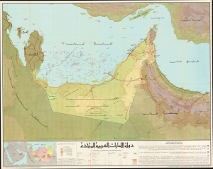
This is a 1973 large-format Arabic-language folding map of the United Arab Emirates compiled by Ezzedin Ibrahim Mustafa and Mohamed Morsy Abdullah. It is the earliest official map of the country and captures it in the months after its creation. (more details)
Stunning Wall Map of Qatar.
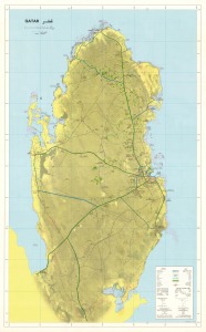
This is a scarce, large-format bilingual wall map of Qatar, produced in 1990 by Clyde Surveys and Qatar's Ministry of Industry and Public Works. It was produced at a time when the country was in the early stages of development of its natural gas industry, which has since become world-leading. (more details)