
1973 Morsy (Morsi) Map of the United Arab Emirates (Arabic Edition)

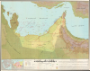
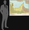
دولة الامارات العربية المتحدة / [United Arab Emirates].
Earliest Official Map of the U.A.E.
Earliest Official Map of the U.A.E.
This is a 1973 large-format Arabic-language folding map of the United Arab Emirates compiled by Ezzedin Ibrahim Mustafa and Mohamed Morsy Abdullah. It is the earliest official map of the country and captures it in the months after its creation.A Closer Look
The map covers the United Arab Emirates and surrounding territories, including Qatar, Bahrain, portions of Oman, Saudi Arabia, and Iran, and the Persian Gulf. Pearl fisheries are indicated in the Gulf, while roads (existing and under construction), tracks, airports, seaports, waterways, terrain, elevation, and other features are indicated. Oil infrastructure (wells, pipelines, pumping stations, refineries) is prominently recorded. An inset map detailing concessions to various oil companies appears to the left of the legend at the bottom, along with a table of oil production between 1962 and 1972 (ranging from less than 1 million long tons per year to more than 57 million, with a small but increasing share from Dubai). An adjacent inset at bottom-left highlights the location of the UAE in a regional context. A block of text discussing the geography, economy, and brief history of the new country at the bottom-right.The Formation of the UAE
In the mid-20th century, the future constituent kingdoms of the United Arab Emirates were the Trucial States along the Persian Gulf coast under British protection, a status that dated back to the early 19th century when Britain sought to secure maritime routes to India. (Technically, the states were part of the East India Company's Persian Gulf Residency and then the Raj, and the Indian rupee was the de facto currency among the territories.) The generally poor pearling and trading societies of the Trucial States began to transform thanks to the discovery of oil off Abu Dhabi in 1958, giving them a growing economic and political significance. In 1968, when Britain announced its intention to withdraw from 'east of Suez' by 1971, Abu Dhabi's ruler, Sheikh Zayed, took the lead in organizing a new political framework to ensure stability after the end of British oversight. Zayed entered negotiations with the rulers of the other Trucial States, as well as Bahrain and Qatar, to form a federation that would balance local autonomy with collective security and development.These efforts culminated in the creation of the UAE on December 2, 1971, one day after formal independence from Britain, when Abu Dhabi and five other emirates (Dubai, Sharjah, Ajman, Umm al-Quwain, and Fujairah) formally united, with Ras al-Khaimah joining in early 1972. Abu Dhabi, the largest and wealthiest emirate, became the capital of the new federation, and Sheik Zayed was chosen as its first president. The constitution of the UAE established a federal system that preserved the sovereignty of each emirate while centralizing key areas such as defense, foreign policy, and economic coordination. Abu Dhabi's oil wealth and Zayed's leadership provided the financial and political foundation for the federation's early stability and rapid modernization.
Publication History and Census
This map was prepared by Ezzedin Ibrahim Mustafa (عز الدين إبراهيم) and Mohamed Morsy Abdullah in 1973. It utilized cartographic work undertaken by Fairey Surveys and was printed by George Philip and Son (جورج فيليب وابنه), with calligraphic work by Salah al-Shami (صلاح الشامي) in Beirut. An English edition was also published the same year (OCLC 925354327). The OCLC notes three examples of the Arabic-language map, held at the University of Chicago, the University of Exeter, and NYU-Abu Dhabi; however, all three institutions catalog it with a date of 1974, suggesting a second edition. We have been unable to locate any other examples of this 1973 edition.Cartographers
Mohamed Morsi Abdullah (December 18, 1929 - October 4, 2005; محمد مرسي عبد الله) was an Egyptian-Emirati historian and cartographer who was one of the earliest social scientists in the United Arab Emirates. He was born in Beni Suef, Egypt to a middle-class family, with his father serving as a police officer and later a government administrator and his mother coming from an esteemed family that was descended from the Prophet Mohammed (thus Abdullah was sometimes known as Sharif Mohamed Morsi Abdullah). Abdullah enrolled at Cairo University as an engineer, but soon switched to the liberal arts, focusing on history. After graduation, he worked in the tourism sector and as a teacher in several countries, eventually becoming a high school principal in Doha, Qatar. Abdullah became convinced that Arabs needed to write their own history rather than leave the task to Western historians, and thus he earned a master's degree in at the University of Cairo in 1965 with a thesis on Saudi-Omani relations, utilizing British, French, and Ottoman archives. Due to his expertise on international relations on the Arabian Peninsula, he was recruited to work in a Documents and Research Bureau (مكتب الوثائق والدراسات, forerunner to the U.A.E. National Archives), where he prepared the first official maps of Abu Dhabi and the United Arab Emirates. Abdullah was encouraged by Zayed bin Sultan Al Nahyan, the ruled of Abu Dhabi and the first President of the United Arab Emirates, to pursue a doctoral degree at the University of Cambridge, which he completed in 1975. Soon before completing his degree, Abdullah was appointed the Director General of the Documents and Research Bureau, a position he held until 1999. Abdullah was an active historian who published several books on the history and foreign relations of the United Arab Emirates and Abu Dhabi specifically. Further Details...
Ezzedin Ibrahim Mustafa (عز الدين إبراهيم x; 1928 - January 30, 2010), also known as Sheikh Ezzedin Ibrahim, was a prominent Egyptian-born educator and political activist who was active in the Muslim Brotherhood for many years. Mustafa attended the University of Cairo and Ain Shams University, and in his youth became a close disciple of Muslim Brotherhood founder Hasan al-Banna. Mustafa impressed al-Banna and other Brotherhood leaders with his eloquence and erudition, gaining him wide attention in the movement despite his youth. When the Brotherhood was suppressed in 1952, Mustafa fled to Libya and played a key role in establishing the Brotherhood in that country (with the support of King Idris I). After briefly returning to Egypt in 1954, he then moved throughout the region, undertaking political activism and charitable works in Syria, Qatar, Saudi Arabia and the United Arab Emirates. He also received a doctorate in literature from the University of London in 1963. Most of his work dealt with education, such as compiling textbooks and curricula for the Ministry of Education in Qatar, or serving as a Professor of Arabic Literature at Riyadh University. Mustafa was a close cultural advisor to Zayed bin Sultan Al Nahyan, the founder of the United Arab Emirates, and lived most of the second half of his life in the U.A.E. He also became a prominent proponent of interfaith dialogue among the three Abrahamic faiths. Further Details...
Fairey Surveys (1923 - 1990) was a pioneer in the field of aerial surveying. The company began life as the independent Air Survey Company, operating in Burma, where traditional survey methods were extremely difficult given the terrain and elevation. The company's first major project was to map the Irrawaddy Delta, and it quickly expanded afterwards, setting up operations in Malaya, India, Egypt, and Britain itself. In 1929, the Air Survey Company became a subsidiary of the British aircraft manufacturer Fairey Aviation Company and expanded operations further, particularly in Africa and the Middle East. In subsequent years, some branches of the Air Survey Co. became subsidiaries in their own right, such as Air Survey Company of India. In 1956, the parent company was renamed Fairey Air Surveys, later simply Fairey Surveys, and its headquarters moved to Maidenhead, Berkshire. In 1977, the Fairey Group went into receivership and its components nationalized or sold off. The air surveying units were purchased by Clyde Petroleum, becoming Clyde Surveying Services Ltd., but by 1990 this company had ended operations. Further Details...
George Philip (1800 - 1882) was a map publisher and cartographer active in the mid to late-19th century. Philip was born into a Calvinst family in Huntly, Aberdeenshire, Scotland. Around 1819 he apprenticed himself to William Grapel, a Liverpool printer and bookseller. Fifteen years later, in 1834, Philip founded his own Liverpool book and map firm. Philip's earliest cartographic ventures were mostly educational material issued in tandem with John Bartholomew Sr., August Petermann, and William Hughes. In 1848, Philip admitted his son, George Philip Jr. (1823 - 1902) into the firm, renaming it George Philip and Son Ltd. George Philip Jr. ran the firm until his death in 1902, by which time it had developed into a major publishing concern. His successors established the London Geographical Institute, a factory where they embraced modern printing techniques to produce thousands of economical and high quality maps. In April 1988, George Philip & Son was acquired by Octopus Publishing, a branch of Reed International. Nonetheless, today the firm trades and publishes to this day as George Philip and Son. Further Details...
Condition
Fine.
References
OCLC 47085120.