
Flahaut, Jacques-Michel

Jacques-Michel Flahaut (1791 - March 20, 1864) was a Paris-based French engraver active in the middle part of the 19th century. Flauhat was born in Paris and worked extensively in Paris mapmaking communities. He engraved for Pierre M. Lapie (fl. 1779 - 1850) and his son Alexandre Emile Lapie (fl. 1809 - 1850), as well as for Adolphe Hippolyte Dufour (1795 - 1865), and Jean Andriveau-Goujon. He was based at 9 Rue de L'est.
After Guadalupe Hidalgo, before the Compromise.
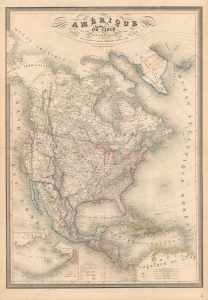
Amérique du Nord par A. H. Dufour...
$1,200.00
Acquire
- Digital Map Information
- Suitable for large format printing
- DPI: 600
- File Size: 144.18 MB
- File Type: ZIP / TIFF
- ICC color profile embedded
- Delivered instantly via download link
A fine example of A. H. Dufour's 1849 map of North America, including Texas with ambitious boundaries. The map offers an interesting and ephemeral look at the Transmississippi in the year after the Treaty of Guadalupe Hidalgo, but before the changes wrought by the Compromise of 1850, the Gold Rush, and in the same year, the statehood of California. (more details)
Matched pair of beautiful, large maps of the Americas.
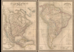
Amérique du Nord. / Amérique du Sud.
$3,500.00
Acquire
- Digital Map Information
- Suitable for large format printing
- Full resolution TIFF file
- ICC color profile embedded
- Delivered instantly via download link
This is a beautiful 1851 pair of A. H. Dufour large-format folding maps of North America and South America, presented together in an original slipcase. The North America map captures an ephemeral look at the Transmississippi in the year after the Treaty of Guadalupe Hidalgo - including a most unusual mapping of the borders of Texas.The South America map shows the political divisions just prior to the Platine War, between the Empire of Brazil and the Argentine Confederation. (more details)