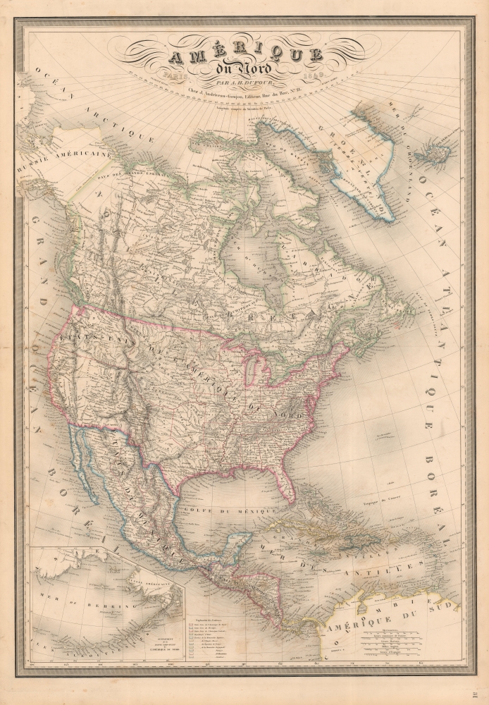
1849 Dufour Map of North America w/ Republic of Texas
AmeriqueNordTexas-dufour-1849$1,200.00


Title
Amérique du Nord par A. H. Dufour...
1849 (dated) 37 x 26 in (93.98 x 66.04 cm) 1 : 10256000
1849 (dated) 37 x 26 in (93.98 x 66.04 cm) 1 : 10256000
Description
A fine example of A. H. Dufour's 1849 map of North America, including Texas with ambitious boundaries. The map offers an interesting and ephemeral look at the Transmississippi in the year after the Treaty of Guadalupe Hidalgo, but before the changes wrought by the Compromise of 1850, the Gold Rush, and in the same year, the statehood of California.
Lands to the west including California remain in the vast largely uncharted block acquired by the United States at the end of the Mexican-American War (1846 - 1848). John Augustus Sutter's (1803 - 1880) colony of New Helvetica, where gold was being discovered as this map went to the presses, is identified. So too is the ‘Colonie Russe' just west along the coast where Fort Ross is named – these lands stopped functioning as a Russian colony in 1841 and in 1849, when this map was printed, were sold to the aforementioned John Sutter for ‘notes and gold'.
Between Oregon and the Missouri River lands are divided into the Mandan, Osage, and Ozark Districts. Although somewhat overlapping and indistinct, these were temporary designations for vast territories occupied by a host of American Indian tribes, as well as tribes relocated there after 1830. Here we can see that many of the districts overlap, not only with one another, but also with newly created encroaching states. The Mandan District is co-labeled 'Nebraska', this being one of the first instances we have identified of the term being used to refer to this region, which, in just 5 years, would be incorporated as Nebraska Territory.
An inset in the lower left corner details the Bering Sea and the Aleutian Islands.
A Closer Look
The map covers the entire North American continent and Greenland, embracing the United States, a newly integrated Texas, Mexico, Canada, Central America, and the Caribbean. Texas extends west nearly to, but not including, Santa Fe – this defies some earlier mappings which pushed the western boundary to the Rio de Norte (Rio Grande), thus creating an unusual stovepipe-like configuration.Lands to the west including California remain in the vast largely uncharted block acquired by the United States at the end of the Mexican-American War (1846 - 1848). John Augustus Sutter's (1803 - 1880) colony of New Helvetica, where gold was being discovered as this map went to the presses, is identified. So too is the ‘Colonie Russe' just west along the coast where Fort Ross is named – these lands stopped functioning as a Russian colony in 1841 and in 1849, when this map was printed, were sold to the aforementioned John Sutter for ‘notes and gold'.
Between Oregon and the Missouri River lands are divided into the Mandan, Osage, and Ozark Districts. Although somewhat overlapping and indistinct, these were temporary designations for vast territories occupied by a host of American Indian tribes, as well as tribes relocated there after 1830. Here we can see that many of the districts overlap, not only with one another, but also with newly created encroaching states. The Mandan District is co-labeled 'Nebraska', this being one of the first instances we have identified of the term being used to refer to this region, which, in just 5 years, would be incorporated as Nebraska Territory.
An inset in the lower left corner details the Bering Sea and the Aleutian Islands.
Texas Borders
The borders of the Republic of Texas were in dispute from the earliest days of the Texan Revolution. The Republic-claimed borders followed the Treaties of Velasco between the newly created Texas Republic and Mexican leader, Antonio López de Santa Anna. The treaties established an eastern boundary following the 1819 Adams-Onís Treaty between the United States and Spain, which established the Sabine River as the eastern boundary of Spanish Texas and western boundary of the Missouri Territory. The Republic's southern and western boundary with Mexico was more nuanced. Texas claimed the Rio Grande del Norte as its western and southernmost border, while Mexico argued for a boundary much further east at the Nueces River. When Texas was annexed into the United States, the agreement followed the Republic claimed boundary, thus absorbing Mexican claimed territory as far west as Santa Fe. This escalated already existing tensions between the United States, the former Republic of Texas, and Mexico, ultimately triggering for the Mexican-American War (1846 - 1848).Publication History and Census
This map was published in 1849 by Jean Andriveau-Goujon. It was drawn by Adolphe Hippolyte Dufour (1795 - 1865), also known as Auguste-Henri Dufour, and engraved by Jacques-Michel Flahaut. The typography is the work of one 'Warin', or possibly 'Varin', who remains elusive. Variants of the map date to as early as 1829, possibly slightly earlier, and as late as 1887. The map was not updated between 1836 and 1848 (per Rumsey), but this present example, 1849, exhibits significant updates and revisions reflecting the end of the Mexican-American War. It was issued both in the Andriveau-Goujon / Dufour Atlas de Choix, ou Recueil des Meilleures Cartes de Geographie Ancienne et Moderne Dressees par Divers Auteurs, and separately as a dissected folding map. While the atlas and the individual maps in it are not rare in late editions, editions with maps depicting Texas between 1836 and 1849 are scarce. We note no separate examples of the map or the atlas in the OCLC from 1836 - 1849.CartographerS
Adolphe Hippolyte Dufour (1795 - 1865), also known as Auguste-Henri Dufour, was a Paris based map and atlas publisher active in the middle to late 19th century. Dufour claimed to be a student of another French cartographer, Emile Lapie. He is known to have worked with numerous other French cartographers, publishers, and engravers of the period including Andriveau-Goujon, Charles Dyonnet, and Duvotenay. His corpus includes numerous maps and atlases, the most striking of which is probably his monumental elephant folio Atlas Universel Physique, Historique et Politique Geographie Ancienne et Moderne. Dufour's student and successor was Alexandre Vuillemin. More by this mapmaker...
Eugène Andriveau-Goujon (1832 - 1897) was a map publisher and cartographer active in 19th century Paris. The firm was created in 1825 when Eugène Andriveau married the daughter of map publisher Jean Goujon - thus creating Andriveau-Goujon. Maps by Andriveau-Goujon are often confusing to identify as they can be alternately singed J. Goujon, J. Andriveau, J. Andriveau-Goujon, E. Andriveau-Goujon, or simply Andriveau-Goujon. This refers to the multiple generations of the Andriveau-Goujon dynasty and the tendency to republish older material without updating the imprint. The earliest maps to have the Andriveau-Goujon imprint were released by Jean Andriveau-Goujon. He passed the business to his son Gilbert-Gabriel Andriveau-Goujon, who in 1858 passed to his son, Eugène Andriveau-Goujon, under whose management the firm was most prolific. Andriveau-Goujon published numerous fine pocket maps and atlases throughout the 19th century and often worked with other prominent French cartographers of the time such as Brue and Levasseur. The firm's stock was acquired by M. Barrère in 1892. Learn More...
Jacques-Michel Flahaut (1791 - March 20, 1864) was a Paris-based French engraver active in the middle part of the 19th century. Flauhat was born in Paris and worked extensively in Paris mapmaking communities. He engraved for Pierre M. Lapie (fl. 1779 - 1850) and his son Alexandre Emile Lapie (fl. 1809 - 1850), as well as for Adolphe Hippolyte Dufour (1795 - 1865), and Jean Andriveau-Goujon. He was based at 9 Rue de L'est. Learn More...
Source
Atlas de Choix, ou Recueil des Meilleures Cartes de Geographie Ancienne et Moderne Dressees par Divers Auteurs, (Paris: Andriveau-Goujon) 1842.
The Atlas de Choix, ou Recueil des Meilleures Cartes de Geographie Ancienne et Moderne Dressees par Divers Auteurs was introduced by Jean Andriveau-Goujon and Adolphe Hippolyte Dufour (Auguste-Henri Dufour; 1795 - 1865) around 1829. It was their finest atlas and arguable the best mid-19th century French atlas. It was a lavishly produced elephant folio containing as many as 60 steel plate (later lithograph) maps of all parts of the world. The atlas had a long print run - more than 55 years - being taken over by Jean Andriveau-Goujon's successors, Gilbert-Gabriel Andriveau-Goujon and Eugène Andriveau-Goujon. Unlike many French atlases of the period, this grand atlas enjoyed regular updates and revisions intended to keep it current.
Condition
Very good. Minor toning. Some offsetting. Wear on old centerfold.
References
Rumsey 12050.060 (1852 edition).