
Frentzel, Georg Friedrich Jonas

Georg Friedrich Jonas Frentzel (1754 - 1799) was a German master engraver from Leipzig. Nothing is published about his early life and education, but his surviving work is superbly detailed and well-executed. He is best known for having engraved one of the finest maps of Boston to be produced in the Revolutionary War period, his 1776 Carte von dem Hafen und der Stadt Boston; he also produced polar projections showing Cook's discoveries in the Pacific Ocean, and a monumental 20-sheet map of Bohemia and Saxony tracing the maneuvers of the War of the Bavarian Succession. All of Frentzel's work is rare on the market.
A unique challenge to the motivated collector.
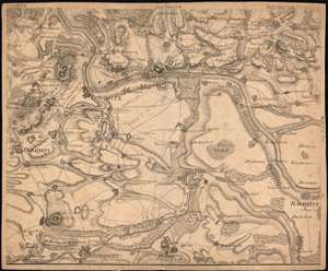
Sectio XVII. [Carte chorographique et Militaire de la partie de la Saxe et de la Bohème par où les Armées combinées de Prusse et de Saxe sont entrées en Bohème aux Ordres de Son Alt. Roi Mgr. Le Prince Henri de Prusse en 1778]
$550.00
Acquire
- Digital Map Information
- Suitable for large format printing
- Full resolution TIFF file
- ICC color profile embedded
- Delivered instantly via download link
This is a 1780 Georg Friedrich Jonas Frentzel map of a portion of Northern Bohemia, recording the positions of armies during the course of the War of the Bavarian Succession (1778 - 1779). The map shows a portion of what is now the Czech Republic, north of Prague at juncture of the River Elbe and the Eger River (more commonly known as the Ohre). It includes the cities of Roudnice, Litomerice, Lovosice, Trebenice, Budyne and Libochovice, as well as many villages. Topography is shown with hachure; forests are shown pictorially. The positions of belligerents are noted, naming the commanders of the armies in many cases, with their positions dated to indicate changes. The movements of the armies under Prince Henry of Prussia, led by Lieutenant Generals Friedrich von Platen and Wichard Joachim Heinrich von Möllendorf, are shown in dates of August and September of 1778. The Austrian positions, commanding the heights west of Litomerice, are simply marked 'Retrenchment de l'ennemi', marking this map's creator as a supporter of the Prussian cause. (Frentzel was a Saxon.) (more details)