
Geological Survey Department, Malaya

Geological Survey Department, Malaya (1903 - present) is the government body in Malaysia, and previously in British Malaya, tasked with technical functions related to minerals, geoscience, mining, and quarrying. Its history began in 1903 with the founding of the Geological Office in Kuala Lumpur, with John Brooke Scrivenor (1876 - 1950) being appointed the head of the office and the first geologist employed by the colonial state in Malaya. In 1908, the Geological Office was moved to Batu Gajah, Perak to oversee field investigations into the potential for tin mining in the region. In the following years, it helped to facilitate the development of Malaya into a mining and export powerhouse, with Scrivenor publishing a series of pioneering studies on the geology of the Malay Peninsula. In 1927, the Geological Office was renamed the Geological Survey Department, and soon thereafter, in 1931, Scrivenor stepped down as the Survey's director. In 1949, a distinct survey was established for Borneo (it later was reincorporated when Sabah and Sarawak joined the Federation of Malaya) and in 1957, the same year Malaysia achieved independence, the Geological Survey Headquarters moved to Ipoh, Perak. In 1973, the Survey's headquarters returned to Kuala Lumpur. Today, the body is known as the Jabatan Mineral dan Geosains Malaysia (JMG), also using the English name Department of Mineral and Geoscience Malaysia.
Mining and Land Use in the Postcolonial Age.
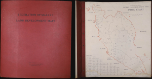
This is a rare 1961 atlas of land development (i.e., land use) in the newly independent Federation of Malaya, prepared by the Federation's Geological Survey Department under the leadership of Joseph B. Alexander. Focusing on mining and mineral exploitation, the 56 maps provide a remarkably comprehensive overview of the Federation's constituent parts in the years just after independence. Both the content and production (overseen by a British geologist) reflect the distinctive, gradual transition away from colonialism on the Malay Peninsula. (more details)