
Hartmann, Elisabeth

Elisabeth Hartmann (née Harder) (April 15, 1861 - December 15, 1913) was a German citizen who created at least one map. Born in Neuwied am Rhein, Germany, she married Martin Hartmann (December 9, 1851 - December 5, 1918) on March 9, 1892. Hartmann drew the Karte des Liwa Haleb und eines Theiles des Liwa Dschebel Bereket in 1894 and it was published in the Zeitschrift der Gesellschaft für Erdkunde zu Berlin. Very little information is available about her life or other work.
One of the first scientific maps of northern Syria and southern Turkey.
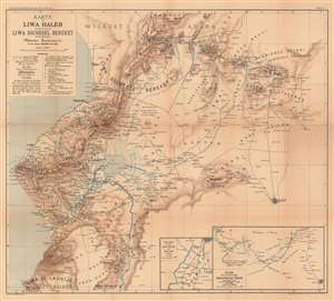
Karte des Liwa Haleb und eines Theiles des Liwa Dschebel Bereket nach den Reisewegen Martin Hartmann's in den Jahren 1882/1883 und 1884.
$450.00
Acquire
- Digital Map Information
- Suitable for large format printing
- File Size: 38.14 MB
- File Type: ZIP / TIFF
- ICC color profile embedded
- Delivered instantly via download link
This is an 1894 Hartmann map of the eastern part of the Vilayet of Aleppo (Haleb), former Ottoman Empire, which encompasses parts of modern-day Turkey and Syria. The map depicts from the southern extreme of the Vilayet of Adana south to Aleppo (now in Syria) and the border of the Vilayet of Beirut. Cities and towns are labeled throughout, including Iskenderun, Pajas, Aleppo (labeled here as Haleb), and Antakija. (As an aside, Iskenderun was known as Alexandretta from the Middle Ages until the Ottoman conquest of Syria and was made famous by Indiana Jones and the Last Crusade. Hartmann, in his article, refers to the city as Alexandrette.) Insets in the lower right corner focus on the city of Antakija and the route between Iskenderun and Aleppo, respectively. (more details)