
Hyde and Company (Belcher Hyde Map Company)

Hyde and Company (fl. c. 1880 - 1920) (a.k.a. E. Belcher Hyde Map Company) was a Brooklyn, New York, publisher of maps and atlases. Hyde's work primarily focused on Long Island and the fire insurance industry, which required highly detailed maps of cities and towns in order to assess risk and liability. Many of Hyde's maps offered incredible detail at a large scale, including annotations on property owners, building materials, size, and function. While Long Island was the focus of most of the firm's efforts, it also produced atlases of the greater New York City metropolitan area, including the Bronx, Queens, Manhattan, and Westchester.
AKA: Belcher Hyde Map Company
A wonderfully detailed map of Fire Island - illustrates numerous private land holdings and residences.
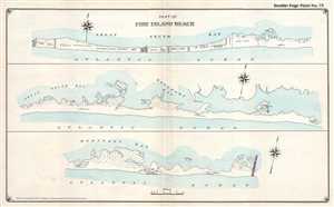
Part of Fire Island Beach.
$350.00
Acquire
- Digital Map Information
- Suitable for large format printing
- File Size: 5.28 MB
- File Type: ZIP / TIFF
- ICC color profile embedded
- Delivered instantly via download link
This is a 1915 E. Belcher Hyde map of part of Fire Island, New York. The map depicts the region in three sections: the first section stretches from the Cherry Grove Hotel to east of the property of E.S. Robinson, the second continues from where the first left off ... (more details)