1915 Hyde Map of Part of Fire Island, New York
FireIslandBeach-hyde-1915$350.00

Title
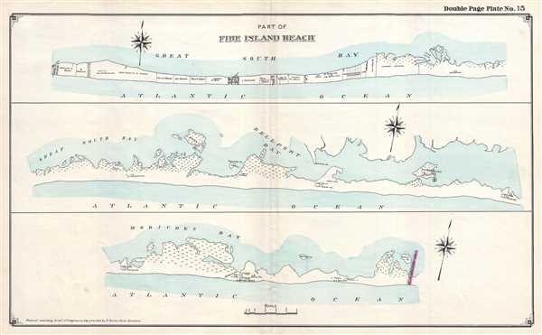
Part of Fire Island Beach.
1915 (dated) 16 x 25.75 in (40.64 x 65.405 cm) 1 : 24000
1915 (dated) 16 x 25.75 in (40.64 x 65.405 cm) 1 : 24000
Description
This is a 1915 E. Belcher Hyde map of part of Fire Island, New York. The map depicts the region in three sections: the first section stretches from the Cherry Grove Hotel to east of the property of E.S. Robinson, the second continues from where the first left off to the Forge River U.S. Life Saving Station, and the third illustrates from the Forge River U.S. Life Saving Station to the boundary between the Town of Brookhaven and the Town of Southampton. Each section illustrates the entirety of Fire Island from the bays separating the island from Long Island to the Atlantic Ocean.
Unlike the other two sections, the first is divided into private properties owned by individuals. The properties vary in size, but each one bears the name of its owner. The town of Water Island, however, is situated in the middle of the first section, creating an unexpected grid of roads among the continuous line of private lots. The Great South Bay is illustrated along the north side of the island, as is Long Cove.
No private property is illustrated on the second section, other than what appear to be two private structures, possibly cabins. The rest is left open, creating the presumption that it was public property. Patersquash Island is illustrated to the north of this second section, as is Ridge Island, Bellport Bay, and Pelican Island. Three U.S. Life Saving Stations are also noted here.
On the third section, the Cupsogue Beach is labeled, along with several houses, including one belonging to W. Pelly and G. Pike. Pike's Beach is labeled to the east of Cupsogue Beach and appears to continue until the border between Brookhaben and Southampton.
This map was created and published by the E. Belcher Hyde Company of Brooklyn, New York in 1915.
Cartographer
Hyde and Company (fl. c. 1880 - 1920) (a.k.a. E. Belcher Hyde Map Company) was a Brooklyn, New York, publisher of maps and atlases. Hyde's work primarily focused on Long Island and the fire insurance industry, which required highly detailed maps of cities and towns in order to assess risk and liability. Many of Hyde's maps offered incredible detail at a large scale, including annotations on property owners, building materials, size, and function. While Long Island was the focus of most of the firm's efforts, it also produced atlases of the greater New York City metropolitan area, including the Bronx, Queens, Manhattan, and Westchester. More by this mapmaker...
Condition
Very good. Verso repairs to centerfold separations. Closed margin tears professionally repaired on verso. Blank on verso.