
Ishida Eisuke (石田英助)

Ishida Eisuke (石田英助; 1914 - 2010) was a Japanese artist who made several maps during the Second Sino-Japanese War, but is best known for his drawings in the publication Boys' Club (少年倶樂部) during the war and publishing manga in a variety of formats in the postwar period (late 1940s – 1960s).
AKA: 石田英助
The Sino-Japanese War situation in 1937 in cartoonish detail. Issued for Japanese women – suggestive of the social changes to traditional gender roles brought about by the war.
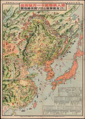
一目でわかる支那事件と日ソ關係繪地圖 / [The China Incident and Japan-Soviet Relations at a Glance].
$850.00
Acquire
- Digital Map Information
- Suitable for large format printing
- Full resolution TIFF file
- ICC color profile embedded
- Delivered instantly via download link
This is a colorful, richly illustrated November 1, 1937 (Showa 12) Ishida Eisuke propaganda manga map of China, Korea, Manchuria, and Japan in the early months of the Second Sino-Japanese War (1937 - 1945). Despite the cartoonish figures, the topic was deadly serious and Ishida was able to include or allude to a great deal of information on military affairs and geopolitics while also conveying the Japanese, or at least the Japanese government's, views on the war. (more details)
Putting a Happy Face on a War of Conquest.
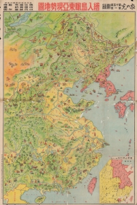
繪入鳥瞰東亞現勢地圖 / [Illustrated Bird's Eye View of the Current Situation in East Asia].
$500.00
Acquire
- Digital Map Information
- Suitable for large format printing
- File Size: 38.74 MB
- File Type: ZIP / TIFF
- ICC color profile embedded
- Delivered instantly via download link
An impressive large-format 1939 manga propaganda map of China and Korea compiled by a team led by political activist and union organizer Sengoku Kotaro and published as a supplement to the periodical Ie no hikari. It was published at the height of the Second Sino-Japanese War (1937 - 1945) (the Chinese theater of World War II), as Japan's initial advances slowed, and the war settled into a grueling stalemate. (more details)