
Jenner, Thomas

Thomas Jenner (c. 1610 - 1673) was an English author, engraver, and publisher in London.
He was a Puritan publisher, and a promoter of Protestant patriotic goals; he would become an outspoken Parliamentarian during the English Civil War (1642 - 1651). Amongst the emblem books, sermons, and other moralistic works, he also produced an improved version of Matthew Simons' Direction for the English Traviller, the first pocket road atlas of England. He also published Wenceslas Hollar's Quartermaster's Map, a map used by both sides in the English Civil War.
The English Civil War.
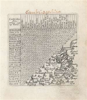
Cambridge Shire : wth. some confinig townes.
$200.00
Acquire
- Digital Map Information
- Suitable for large format printing
- Full resolution TIFF file
- ICC color profile embedded
- Delivered instantly via download link
This is a 1643 Thomas Jenner county map of Cambridgeshire, England. It combines a triangular table showing the distances between towns with a small map in the lower right. The map is Spartan, but well-engraved. A scale is indicated with a mapmaker's compass in the map's lower left corner. It includes part of Norfolk, reaching as far north as Snettisham, and The Wash; in the southwest the map encompasses Bedfordshire, at its extreme including the town of Buckingham. (more details)