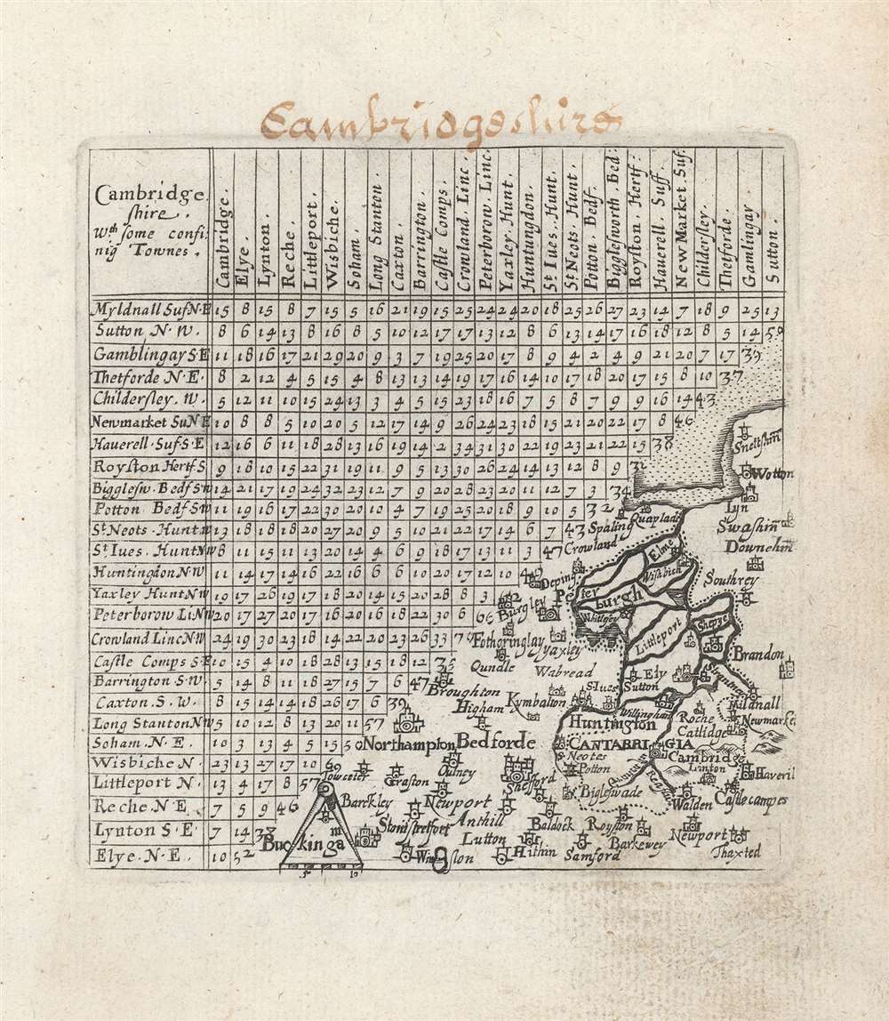
1643 Thomas Jenner/ van Langeren Miniature Map of Cambridgeshire
Cambridgeshire-jenner-1743$200.00


Title
Cambridge Shire : wth. some confinig townes.
1743 (undated) 4.5 x 4 in (11.43 x 10.16 cm) 1 : 545000
1743 (undated) 4.5 x 4 in (11.43 x 10.16 cm) 1 : 545000
Description
This is a 1643 Thomas Jenner county map of Cambridgeshire, England. It combines a triangular table showing the distances between towns with a small map in the lower right. The map is Spartan, but well-engraved. A scale is indicated with a mapmaker's compass in the map's lower left corner. It includes part of Norfolk, reaching as far north as Snettisham, and The Wash; in the southwest the map encompasses Bedfordshire, at its extreme including the town of Buckingham.
From the First Pocket-Atlas of England
In 1625, John Norden published England. An Intended Guyde for English Travailers, which introduced a series of triangular tables allowing the reader to calculate distances between the towns. The book lacked maps, an oversight remedied in 1635 with the publication by Mathew Simons of a new edition entitled A Direction for the English Traviller whose tables, engraved by Jacob van Langeren incorporated maps. The work was the first pocket-sized road atlas, and was popular enough to be reprinted three more times in the seventeenth century. The maps were thumbnail references appearing on William Bowes' 1590 map playing cards. When the London publisher and Parliamentarian supporter Thomas Jenner reissued the work in 1643, he had the Van Langeren plates reengraved to include more up-to-date cartography based on John Speed's county maps.A Partisan Work
Jenner's edition of A Direction for the English Traviller was notable for having been published during the English Civil War; Jenner himself was both a Puritan, and a fierce Parliamentarian. His intention in updating the maps in this work were to make it useful to the Parliamentarian army in the field. The scale of the map appears to stand in direct conflict with its utility to casual traveler or field commander alike, but the best printed maps available - mainly Speed's - were both unwieldy and expensive, so even as rudimentary a map as this may have had value.Publication History and Census
Jenner's A Direction for the English Traviller was printed in 1643, with further editions printed in 1657 and 1677; the work was also republished under the title A book of the names of all parishes, market towns, villages, hamlets, and smallest places, in England and Wales in those same years, as well as 1662 and 1668. Both books are well represented in institutional collections. We see just one example of the separate map, cataloged at Oxford.Cartographer
Thomas Jenner (c. 1610 - 1673) was an English author, engraver, and publisher in London. He was a Puritan publisher, and a promoter of Protestant patriotic goals; he would become an outspoken Parliamentarian during the English Civil War (1642 - 1651). Amongst the emblem books, sermons, and other moralistic works, he also produced an improved version of Matthew Simons' Direction for the English Traviller, the first pocket road atlas of England. He also published Wenceslas Hollar's Quartermaster's Map, a map used by both sides in the English Civil War. More by this mapmaker...
Condition
Very good. Lightly soiled in margins, ms. title added at top border.
References
OCLC 43178143.