
Jolivet, Jean

Jean Jolivet (fl. 1545-1569) Was a French priest and cartographer. Nothing biographically is known of the man, except that he was a cartographer to Frances II, King of France from 1559 to 1560. In 1545 he produced a six-sheet printed map of Berry which is now known in a single copy. His map of France, a woodcut on four sheets, was printed in 1560; this issue was also only known in a single survival, but this is now lost. However this, and the area maps of Bourges, Normandy and Picardy, were at one time well known and provided the source for maps of those regions by Ortelius and De Jode.
The First Atlas Map of France.
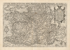
Galliae Regni Potentiss. Nova Descriptio.
$500.00
Acquire
- Digital Map Information
- Suitable for large format printing
- DPI: 600
- File Size: 51.37 MB
- File Type: ZIP / TIFF
- ICC color profile embedded
- Delivered instantly via download link
This is Abraham Ortelius' 1570 map of France, based on the now-lost 1560 Nouvelle Description des Gaules of French priest and cartographer Jean Jolivet. The map includes the areas that would become Switzerland and Savoy, as well as Italy's Piedmont and part of Lombardy. Franz Hogenberg's expert engraving includes the evocative, pictorial representation of the Alps and the Pyrenees mountain ranges, as well as forests throughout northern France. Descriptive notes in French appear throughout.
(more details)