1570 Ortelius Map of France
France-ortelius-1570$500.00

Title
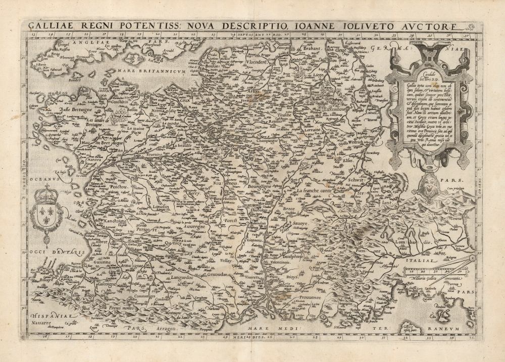
Galliae Regni Potentiss. Nova Descriptio.
1570 (undated) 13.75 x 19.75 in (34.925 x 50.165 cm) 1 : 3900000
1570 (undated) 13.75 x 19.75 in (34.925 x 50.165 cm) 1 : 3900000
Description
This is Abraham Ortelius' 1570 map of France, based on the now-lost 1560 Nouvelle Description des Gaules of French priest and cartographer Jean Jolivet. The map includes the areas that would become Switzerland and Savoy, as well as Italy's Piedmont and part of Lombardy. Franz Hogenberg's expert engraving includes the evocative, pictorial representation of the Alps and the Pyrenees mountain ranges, as well as forests throughout northern France. Descriptive notes in French appear throughout.
Publication History and Census
This map was engraved by Franz Hogenberg for inclusion in Ortelius' Theatrum Orbis Terrarum in 1570. The present example conforms typographically to the 1581 French text edition, of which van den Broecke estimates there were four hundred printed. The map would be replaced by Vrients beginning in 1608 by a new map based on a newer map derived from Postel. Nine examples of the 1581 edition of the atlas are listed in OCLC. The separate map is well represented in institutional collections.CartographerS
Abraham Ortelius (April 14, 1527 - June 28, 1598) also known as Ortels, was a cartographer, geographer, and cosmographer of Brabant, active in Antwerp. He was the creator of the first modern atlas, Theatrum Orbis Terrarum and is a seminal figure in the history of cartography. Along with Gerard Mercator and Gemma Frisius, he was a founder of the Netherlandish school of cartography. His connections with Spain - culminating in his 1575 appointment as Royal Cartographer to King Phillip II of Spain - gave him unmatched access to Spanish geographical knowledge during a crucial period of the Age of Discovery. Ortelius was born in 1527 in Antwerp. In 1547 he entered the Antwerp Guild of Saint Luke as an illuminator of maps. He began trading in books, prints, and maps, traveling regularly to the Frankfurt book and print fair, where in 1554 he met Mercator. He accompanied Mercator on journeys throughout France in 1560 and it was at this time, under Mercator's influence, that he appears to have chosen his career as a scientific geographer. His first published geographic work appeared in 1564, an eight-sheet cordiform world map. A handful of other maps preceded the 1570 publication of the first edition of the Theatrum Orbis Terrarum, which would prove to be his life work. Appearing with but 53 maps in its first edition, Ortelius' work expanded with new maps added regularly. By 1592, it had 134 maps. Many of Ortelius' maps remained the standard for nearly a century. He traveled extensively, but his genius was as a compiler, locating the best informed maps on which to base his own. His contacts throughout Europe and extending even (via the Portuguese) to the Far East were formidable. Moreover, many of his maps were based on his own scholarship, particularly his historical works. His theories of geography were particularly ahead of his time with respect to the notion of continental drift, the possibility of which he mused on as early as 1596, and which would be proven correct centuries later.
In a sense his greatest achievement was his successful navigation of the religious and political violence endemic to his city throughout his adult life: The Dutch Revolt, or Eighty Years' War (1568 - 1648), fully embroiled Antwerp. Although outwardly and officially recognized as Catholic (Arias Montanus vouched for Ortelius' Catholic orthodoxy prior to his appointment as Royal Geographer), Ortelius was able to separate himself from the religious furor which characterized the war in the low countries. Ortelius showed a glimpse of himself in a letter to a friend, regarding humanist Justus Lipsius: 'I do not know whether he is an adherent of the Pope or a Calvinist, but if he has ears to hear, he will neither be one nor the other, for sins are committed on both sides'. Ortelius' own explorations of Biblical history in his maps, and the Christogram contained in his own motto, suggest him to be a religious man, but his abjuration of political religious authorities mark him as an individualist. His tombstone at St Michael's Præmonstratensian Abbey in Antwerp bears the inscription, Quietis cultor sine lite, uxore, prole. ('served quietly, without accusation, wife, and offspring.') More by this mapmaker...
Jean Jolivet (fl. 1545-1569) Was a French priest and cartographer. Nothing biographically is known of the man, except that he was a cartographer to Frances II, King of France from 1559 to 1560. In 1545 he produced a six-sheet printed map of Berry which is now known in a single copy. His map of France, a woodcut on four sheets, was printed in 1560; this issue was also only known in a single survival, but this is now lost. However this, and the area maps of Bourges, Normandy and Picardy, were at one time well known and provided the source for maps of those regions by Ortelius and De Jode. Learn More...
Source
Ortelius, A., Theatre de l'univers, contenant les cartes de tout le monde, (Antwerp) 1581.
Condition
Very good. Few faint stains, else excellent.
References
OCLC 179744155. Rumsey 10000.027 (1570) Van den Broecke Ortelius Atlas Maps 34.