
Knight, John

John Knight (1802 - 1872) was an American line and letter engraver based in Philadelphia and Delaware. He worked with Henry Schenck Tanner (1786 - 1858) and late for the U.S. Coast Survey.
Early Appearance of the Wabash and Erie Canal.
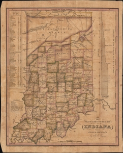
The Travellers Pocket Map of Indiana with its roads and distances. / Indiana Traveller.
$1,200.00
Acquire
- Digital Map Information
- Suitable for large format printing
- File Size: 8.78 MB
- File Type: ZIP / TIFF
- ICC color profile embedded
- Delivered instantly via download link
This is a scarce 1831 pocket map of Indiana prepared by Henry Schenck Tanner and engraved by John Knight. It presents the state as its population was growing rapidly in the wake of statehood and several wars against Native Americans, particularly Tecumseh's Confederacy, which opened most of the state's territory up to settlement. (more details)