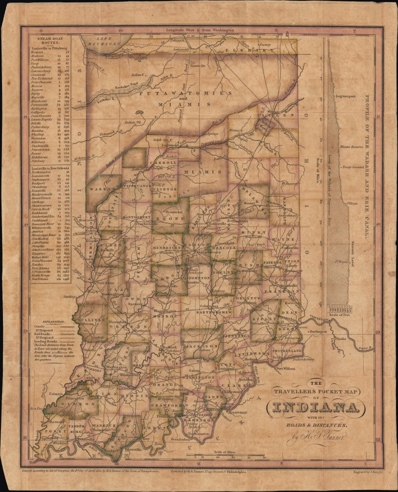
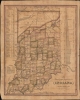
1831 Tanner Pocket Map of Indiana
IndianaPocketMap-tanner-1831$1,200.00


Title
The Travellers Pocket Map of Indiana with its roads and distances. / Indiana Traveller.
1831 (dated) 13 x 10.5 in (33.02 x 26.67 cm) 1 : 1430000
1831 (dated) 13 x 10.5 in (33.02 x 26.67 cm) 1 : 1430000
Description
This is a scarce 1831 pocket map of Indiana prepared by Henry Schenck Tanner and engraved by John Knight. It presents the state as its population was growing rapidly in the wake of statehood and several wars against Native Americans, particularly Tecumseh's Confederacy, which opened most of the state's territory up to settlement.
This map was issued in the wake of the 1826 Treaty of Mississinewas, which forced the Miami and Potowatomi to cede most of their land to the U.S. Government, including the land labeled 'Purchase of 1826' at the top. The treaty also allowed for compensation to Miami Chief Richardville and other Miami notables in the form of estates within Indiana. The tribe also received $31 million. Nonetheless, in the following years, the Potawatomi, Miami, and other indigenous peoples were relocated, either by treaty or by force, west of the Mississippi River, with most of the Miami people ultimately forcibly removed by the U.S. military in October 1846. Small numbers of Potawatomi and Miami were able to secure exemptions from the removals based on earlier treaties; others successfully lobbied the government to return to Indiana after having been relocated to the west.
Construction of the Wabash and Erie Canal began in 1832, with its grand opening on July 4, 1843. Due to Indiana's unique topography, the work necessitated engineering innovations, including swing bridges, systems of counterweights, tumbles, dams, locks, and the development of concrete that could harden under water. The completion of the canal precipitated an economic boom along its route. Not everyone was a fan, though. Some blamed a dam built between 1838 and 1841 along the Wabash River in Carrol County for regional flooding. Angry locals dynamited the dam on February 9, 1881, destroying the canal boat river crossing and ending Pittsburg, Indiana's economic boom.
A vaguely proposed state road also appears here, running north from Indianapolis through a swamp to unspecified 'Settlements' along the St. Joseph's River (laid out the following year as South Bend), and then westward to Lake Michigan. A commission was formed in 1828 to study a route, and in the following years, the Michigan Road was built roughly along these lines laid out here.
A Closer Look
The map presents the state of Indiana with counties color-shaded for distinction. Cities and towns, forts, Indian settlements, frontier outposts, waterways, and roads (with distances between settlements) are labeled throughout. The map is most significant for two features: the evolution of the state (and the country's) frontier and the early appearance of the Wabash and Erie Canal (both discussed below). It also contains information relevant to Abraham Lincoln; as an adolescent and teenager, Lincoln and his family lived in the southern part of the state in Spencer County near Little Pigeon Creek. Aside from the map, a profile of the Wabash and Erie Canal appears on the right, while on the left is a series of tables of steamboat routes, noting the distance of each leg of the given journey and the cumulative distance of the journey from its starting point; tellingly, none of these routes actually reached Indiana itself, but instead left from Louisville, across the Ohio River.American Indian Territory in Indiana
Tanner maps are highly desirable for their unique perspective on American geography during a period of rapid westward expansion, particularly with regard to American Indian lands. After the battles against Tecumseh's Confederacy (the locations of the 1811 Battle of Tippecanoe and the 1812 Battle of the Mississinewa are noted here) and subsequent victories by the American side, vast portions of land in Indiana were opened up to white settlers. The uncertain and rapidly changing territorial situation is evident in the northern part of the state near the 'Indian Boundary,' where demarcated but unlabeled portions of land appear, along with the large Miami Reservation and a smaller one southwest of Fort Wayne.This map was issued in the wake of the 1826 Treaty of Mississinewas, which forced the Miami and Potowatomi to cede most of their land to the U.S. Government, including the land labeled 'Purchase of 1826' at the top. The treaty also allowed for compensation to Miami Chief Richardville and other Miami notables in the form of estates within Indiana. The tribe also received $31 million. Nonetheless, in the following years, the Potawatomi, Miami, and other indigenous peoples were relocated, either by treaty or by force, west of the Mississippi River, with most of the Miami people ultimately forcibly removed by the U.S. military in October 1846. Small numbers of Potawatomi and Miami were able to secure exemptions from the removals based on earlier treaties; others successfully lobbied the government to return to Indiana after having been relocated to the west.
The Wabash and Erie Canal
Extending from the banks of Lake Erie and Toledo, Ohio, over 468 miles to Evansville, Indiana, on the Ohio River, the Wabash and Erie Canal was at the time of its completion the longest fabricated structure in the United States. When this map was made, a land grant had been provided by the U.S. Congress and a board of three commissioners appointed by the Indiana General Assembly, but the canal was still in preliminary planning stages, reflected by its uncertain terminus here somewhere in the vicinity of Logansport.Construction of the Wabash and Erie Canal began in 1832, with its grand opening on July 4, 1843. Due to Indiana's unique topography, the work necessitated engineering innovations, including swing bridges, systems of counterweights, tumbles, dams, locks, and the development of concrete that could harden under water. The completion of the canal precipitated an economic boom along its route. Not everyone was a fan, though. Some blamed a dam built between 1838 and 1841 along the Wabash River in Carrol County for regional flooding. Angry locals dynamited the dam on February 9, 1881, destroying the canal boat river crossing and ending Pittsburg, Indiana's economic boom.
The National Road
The National Road, begun in 1811 and completed in 1837, was the first major improved highway in the United States. The road, illustrated here by a double dashed line along a proposed route running near Centreville to Indianapolis, connected the Ohio and Potomac Rivers and stretched from Cumberland, Maryland, to Vandalia, Illinois, the Illinois state capital at the time (its Indiana portion later included a section from Indianapolis to Terre Haute). Construction of the National Road came to an end when federal funding dried up due to the Panic of 1837. The road became the major overland means of travel between the eastern and western portions of the American Republic, facilitating the transportation of goods and people and leading to the growth of many new cities and towns along its route. However, like the canals, it would later be rendered obsolete by railroads.A vaguely proposed state road also appears here, running north from Indianapolis through a swamp to unspecified 'Settlements' along the St. Joseph's River (laid out the following year as South Bend), and then westward to Lake Michigan. A commission was formed in 1828 to study a route, and in the following years, the Michigan Road was built roughly along these lines laid out here.
Publication History and Census
This map was prepared by Henry Schenck Tanner and engraved by John Knight for publication in 1831. It is rare, with only one institutional record at the University of Illinois at Urbana Champaign and minimal market history.CartographerS
Henry Schenck Tanner (1786 - May 18, 1858) was one of the preeminent American map engravers and publishers of the early 19th century - what is considered to be the "Golden Age of American Map Publishing". Born in New York City but based in Philadelphia, Tanner's forty plus year career was almost entirely focused on cartographic work. His earliest map work appears in conjunction with another important map publisher, John Melish. Early in his career, Tanner partnered with his brother Benjamin, to engrave extensively for Melish as well as other Philadelphia publishers including Lucas Fielding (Baltimore), A. Bourne, Jason Torey, Samuel Harrison, and Samuel Lewis, among others. In 1818 Tanner convinced his fellow publishers and partners to finance the compilation of a New American Atlas. The atlas was sold by subscription and slowly emerged between 1819 and 1823. The New American Atlas, possibly the pinnacle of 19th century American cartography and was commended in its day as "one of the most splendid works of the kind ever executed in this country". It was subsequently republished in several updated editions until about 1839. Tanner had by this time become the most active and influential map publisher in the United States. Around 1832, recognizing the market for a less cost prohibitive atlas, Tanner began work on the smaller format New Universal Atlas. This popular and important atlas went through numerous editions before being bought out by Carey and Hart, and then, in 1846, by S. A. Mitchell, who would rise to become the preeminent publisher of the next generation. In addition to these important atlases, Tanner also issued numerous extremely important and influential travelers guides, state maps, wall maps, and pocket maps. He should not be confused with his brother, also an America map engraver, the New Yorker Benjamin Tanner. More by this mapmaker...
John Knight (1802 - 1872) was an American line and letter engraver based in Philadelphia and Delaware. He worked with Henry Schenck Tanner (1786 - 1858) and late for the U.S. Coast Survey. Learn More...
Condition
Very good. Light wear along original fold lines. Verso repairs to fold separations and at fold intersections. Reinforced where previously attached to binder. Accompanied by original binder.
References
OCLC 1059605726.