
Leclercq, Charles

Charles Leclercq (fl. c. 1825 - 1873), also as Carlos Leclercq, was an engraver of maps and nautical charts, including for the Spanish Dirección General de Hidrografía. Several route maps in French are attributed to him from the 1820s and 1830s, which were published in Paris and Brussels, and which, along with his name, suggest a French or Belgian rather than Spanish origin. From 1841, he began to engrave maps in Spanish, and by 1850 was engraving maps almost exclusively in Spanish, suggesting a relocation to Spain, most likely Madrid. In the mid-1860s, he became a frequent contributor for the Dirección de Hidrografía. He should not be confused with a painter by the same name active in the late 18th and early 19th century who produced portraits of European royalty.
Confederate Camaradas?
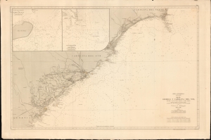
América Septentrional, Costa Este. Hoja III. Georgia y Carolina del Sur desde Savannah hasta cabo Fear.
$1,200.00
Acquire
- Digital Map Information
- Suitable for large format printing
- File Size: 1227.68 MB
- File Type: ZIP / TIFF
- ICC color profile embedded
- Delivered instantly via download link
An intriguing nautical chart or map of the Georgia and South Carolina coasts, produced in 1868 by Spain's Dirección de Hidrografía. Surveyed before the U.S. Civil War but published afterwards, the chart reflects both Spain's investment in naval modernization in the preceding decades and a continued interest in the Americas, despite having lost most of its colonial empire earlier in the century. (more details)