1868 Dirección de Hidrografía Chart of Georgia, South Carolina Coast
GeorgiaSouthCarolina-direccionhidrografia-1868$1,200.00


Title
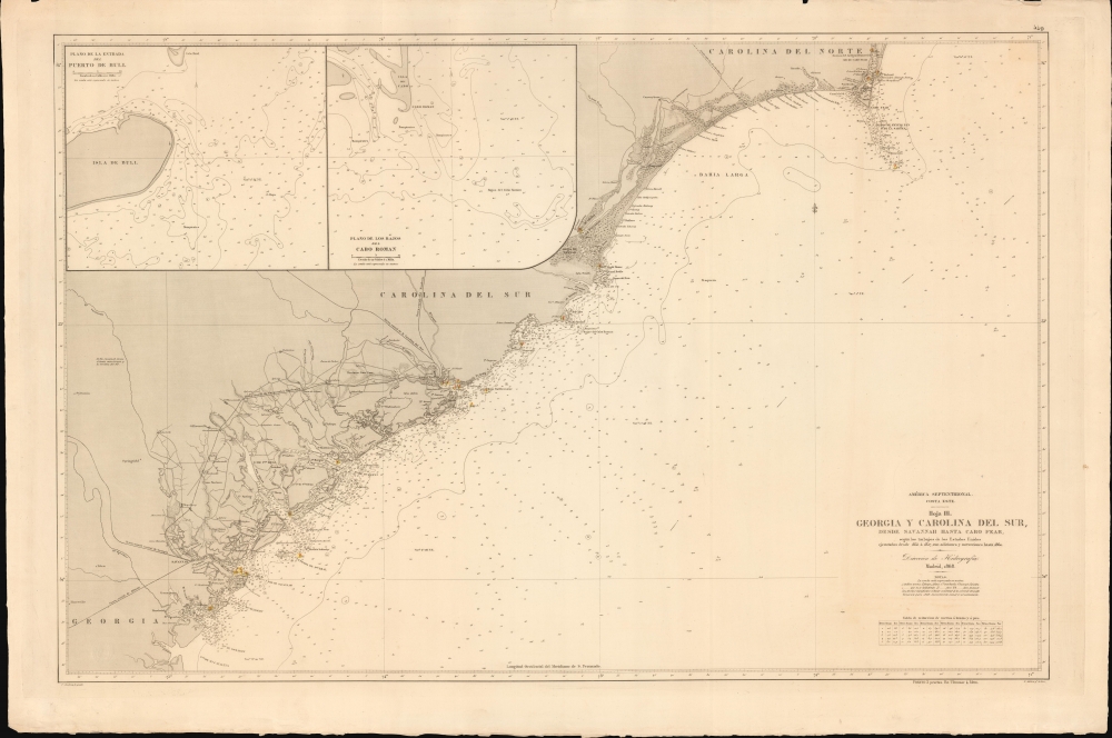
América Septentrional, Costa Este. Hoja III. Georgia y Carolina del Sur desde Savannah hasta cabo Fear.
1868 (dated) 27 x 40.5 in (68.58 x 102.87 cm) 1 : 450000
1868 (dated) 27 x 40.5 in (68.58 x 102.87 cm) 1 : 450000
Description
An intriguing nautical chart or map of the Georgia and South Carolina coasts, produced in 1868 by Spain's Dirección de Hidrografía. Surveyed before the U.S. Civil War but published afterwards, the chart reflects both Spain's investment in naval modernization in the preceding decades and a continued interest in the Americas, despite having lost most of its colonial empire earlier in the century.
When the Civil War broke out in 1861, Spain and the Confederacy seemed like natural allies. Like the Confederacy, Spain was the only European country that continued to support slavery, in its Puerto Rican and Cuban plantations. Nonetheless, like other European powers Spain refused to officially sanction the Confederacy, instead signing a declaration of neutrality in 1861. At the same time, enterprising Spanish merchants and ship owners were not discouraged from running the Union naval blockades to supply the south. Spain also became embroiled in the maddeningly complex CSS Stonewall incident, whereby a ship commissioned by the Confederacy was built in France, then passed around Europe by countries who wanted to avoid any overt support for the rebels. The ship eventually ended up in Spain, where it needed repairs, then sailed to Havana, where it only arrived after the war had ended. It was eventually sold to Spain, and then immediately transferred to the U.S. government for an equivalent sum; afterwards, it was sold to the Tokugawa Shogunate of Japan, seeking in its dying days to modernize its navy.
Returning to the present chart, it is possible that unofficial wartime assistance to the Confederacy was expected to open up postwar trading opportunities in the South. In any event, Spain was certainly interested in and, thanks to this chart, more familiar with the waters off the former Confederate states.
A Closer Look
Ranging from Cape Fear in North Carolina to the mouth of the Ogeechee River just south of Savannah, this chart takes in the entirety of the Atlantic coast of Georgia and much of that of South Carolina. Soundings, currents, shoals, variations, islands, beacons, and lighthouses are noted throughout, as are several other features explained in a legend below the title. On land, cities and towns, railways, roads, rivers, canals, forts, and terrain are indicated. Insets at top-left focus on the waters off Bull Island, Cape Romain, and Cape Island, near Charleston, South Carolina. A table at bottom-right explains conversion between meters, brazas, and feet.Spain and the Confederacy
This chart is based on surveys undertaken before the U.S. Civil War and was published in the immediate aftermath of the war. After having lost most of its American empire in the early 19th century, Spain entered a period of relative political stability and sustained economic growth leading to a strengthening of its naval and military forces. Indeed, under Leopoldo O'Donnell, Spain's navy grew so fast that by 1860, it was the 4th largest naval power in the world. Spain was well positioned to reassert its colonial power, especially with the United States distracted by the Civil War.When the Civil War broke out in 1861, Spain and the Confederacy seemed like natural allies. Like the Confederacy, Spain was the only European country that continued to support slavery, in its Puerto Rican and Cuban plantations. Nonetheless, like other European powers Spain refused to officially sanction the Confederacy, instead signing a declaration of neutrality in 1861. At the same time, enterprising Spanish merchants and ship owners were not discouraged from running the Union naval blockades to supply the south. Spain also became embroiled in the maddeningly complex CSS Stonewall incident, whereby a ship commissioned by the Confederacy was built in France, then passed around Europe by countries who wanted to avoid any overt support for the rebels. The ship eventually ended up in Spain, where it needed repairs, then sailed to Havana, where it only arrived after the war had ended. It was eventually sold to Spain, and then immediately transferred to the U.S. government for an equivalent sum; afterwards, it was sold to the Tokugawa Shogunate of Japan, seeking in its dying days to modernize its navy.
Returning to the present chart, it is possible that unofficial wartime assistance to the Confederacy was expected to open up postwar trading opportunities in the South. In any event, Spain was certainly interested in and, thanks to this chart, more familiar with the waters off the former Confederate states.
Publication History and Census
This chart was produced by the Dirección de Hidrografía in 1868, based on American surveys between 1855 and 1857, with later corrections and additions. This is the third sheet in a series of four, indicating that the Dirección de Hidrografía used the U.S. Coast Survey series 'Atlantic Coast of the United States, in four sheets' as a basis. Charles Leclercq is noted as engraver, while Ramón Albaren undertook letter engraving. The only known institutional holdings of this chart are with the Bibliothèque nationale de France, the Biblioteca Nacional de España, and the Instituto Geográfico Nacional.CartographerS
The Direccion Hidrografía (1787 - 1927), also known as the Deposito Hydrografico and the Direction de Hidrografía, was the Spanish equivalent of the British Admiralty or the U.S. Coast Survey. This organization, founded in 1787, was commissioned to collect and produce accurate nautical charts of all waters frequented by Spanish vessels. In essence, it replaced the Casa de la Contratación de las Indias (House of Trade of the Indies), which closed its doors in 1790. Like most such organizations, the Direccion Hidrografía marked a new age in cartography. Rather than simply collect charts created by navigators, explorers, and merchants, the Direccion Hidrografía worked closely with naval and military personnel to mount cartographic and hydrographic expeditions in pursuit of the most accurate hydrographical, astronomical, and geodetic measurements. The Direccion Hidrografía created a massive library of nautical charts that, though not nearly as common as similar nautical charts by the U.S. Coast Survey and British Admiralty, are highly desirable for the beauty of their manufacture as well as their accuracy and detail. The office was originally located on Calle Ballesta, but relocated to 36 Alcala, both in Madrid. After 1908 the Dirección was subsumed into other governmental agencies. In 1927 the Direccion was absorbed into the Institute and Observatory of San Fernando, located in Cadiz. The library of original maps, charts, and journals was transferred to the Naval Museum of Madrid - where it resides to this day. More by this mapmaker...
Ramón Alabern Y Moles (December 18, 1811 - 1888) was a Catalan map engraver active in Madrid and Barcelona in the early to mid-19th century. Ramón was born in Begues, just outside Barcelona, and initially studied engraving under his older brother, Pablo Alabern Y Moles (1804 - 1860). He afterward traveled to Paris to master to most sophisticated map engraving techniques. There he learnt the daguerreotyping, an early photographic technique, under the technique's inventor, Louis Jacques Mandé Daguerre (1787 - 1851). Returning to Barcelona in 1839, he introduced daguerreotyping to Spain with a dramatic presentation in partnership with the Real Academia de Ciencias Exactas, Físicas y Naturales. Throughout his career, Ramón supplemented his income as a map engraver for the Direccion Hidrografía with photography, publishing several daguerreotype compilations. Alabern died in Madried in 1888. Learn More...
Charles Leclercq (fl. c. 1825 - 1873), also as Carlos Leclercq, was an engraver of maps and nautical charts, including for the Spanish Dirección General de Hidrografía. Several route maps in French are attributed to him from the 1820s and 1830s, which were published in Paris and Brussels, and which, along with his name, suggest a French or Belgian rather than Spanish origin. From 1841, he began to engrave maps in Spanish, and by 1850 was engraving maps almost exclusively in Spanish, suggesting a relocation to Spain, most likely Madrid. In the mid-1860s, he became a frequent contributor for the Dirección de Hidrografía. He should not be confused with a painter by the same name active in the late 18th and early 19th century who produced portraits of European royalty. Learn More...
The Office of the Coast Survey (1807 - present) founded in 1807 by President Thomas Jefferson and Secretary of Commerce Albert Gallatin, is the oldest scientific organization in the U.S. Federal Government. Jefferson created the "Survey of the Coast," as it was then called, in response to a need for accurate navigational charts of the new nation's coasts and harbors. The spirit of the Coast Survey was defined by its first two superintendents. The first superintendent of the Coast Survey was Swiss immigrant and West Point mathematics professor Ferdinand Hassler. Under the direction of Hassler, from 1816 to 1843, the ideological and scientific foundations for the Coast Survey were established. These included using the most advanced techniques and most sophisticated equipment as well as an unstinting attention to detail. Hassler devised a labor intensive triangulation system whereby the entire coast was divided into a series of enormous triangles. These were in turn subdivided into smaller triangulation units that were then individually surveyed. Employing this exacting technique on such a massive scale had never before been attempted. Consequently, Hassler and the Coast Survey under him developed a reputation for uncompromising dedication to the principles of accuracy and excellence. Unfortunately, despite being a masterful surveyor, Hassler was abrasive and politically unpopular, twice losing congressional funding for the Coast Survey. Nonetheless, Hassler led the Coast Survey until his death in 1843, at which time Alexander Dallas Bache, a great-grandson of Benjamin Franklin, took the helm. Bache was fully dedicated to the principles established by Hassler, but proved more politically astute and successfully lobbied Congress to liberally fund the endeavor. Under the leadership of A. D. Bache, the Coast Survey completed its most important work. Moreover, during his long tenure with the Coast Survey, from 1843 to 1865, Bache was a steadfast advocate of American science and navigation and in fact founded the American Academy of Sciences. Bache was succeeded by Benjamin Pierce who ran the Survey from 1867 to 1874. Pierce was in turn succeeded by Carlile Pollock Patterson who was Superintendent from 1874 to 1881. In 1878, under Patterson's superintendence, the U.S. Coast Survey was reorganized as the U.S. Coast and Geodetic Survey (C & GS) to accommodate topographic as well as nautical surveys. Today the Coast Survey is part of the National Oceanic and Atmospheric Administration or NOAA as the National Geodetic Survey. Learn More...
Condition
Very good. Slight toning. Original deckled edges. A few minor chips and small repaired tear to up margin, not affecting printed map.
References
OCLC 807338015. Instituto Geográfico Nacional, S1-35-A-38.