
Ligon, Richard

Richard Ligon (1585 - 1662) was an English businessman, author, polymath, and rake. Ligon was born into an elite royalist family, but lost his fortunes in the English Civil War (1642 - 1651). Ligon was 'the fourth son of a third son' and so inherited 'a respectable name but diluted fortune.' (Parker 39-40). Mired in debt and beset on all side by enemies, Ligon determined to make his fortune in the New World. In 1647, at 60 years of age, he left for the colony of Barbados, acquiring a half-share in a sugar plantation. After two years in the tropical climate, he acquired a persistent fever - likely malaria -, returning to England to recover. Back home, he was immediately arrested by his creditors. While in prison, he complied his notes from Barbados into an important work, A True and Exact History of the Island of Barbadoes, featuring the first specific map of that island. The work was popular, and published in 1657 and again in 1673, before being translated into French for a 1674 edition. The work provides a valuable first-person perspective on the Caribbean sugar trade, the early days of the Sugar Revolution, and 17th century European life in the West Indies.
First French edition of the the earliest specific map of Barbados.
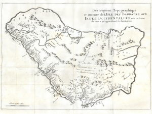
Description Topographique et mesure de LIsle des Barbades aux Indes Occidentalles avec les Noms de ceux a qui appartienent leas habitations.
$2,800.00
Acquire
- Digital Map Information
- Suitable for large format printing
- DPI: 600
- File Size: 146.7 MB
- File Type: TIFF
- ICC color profile embedded
- Delivered instantly via download link
This is the 1675 first French edition of the earliest specific map of Barbados during the Sugar Revolution. The map is based upon Richard Ligon's 1657 map, composed from information received in Barbados from Captain John Swan, the island's leading surveyor. Ligon compiled it in debtor's prison after returning to London from a 2-year stint as a planter in Barbados. The map is oriented to the east and offers fair accuracy, though it exaggerates the island's length by roughly a third. The map identifies numerous plantations throughout by name, as well as the beginnings of Bridgetown as 'Bridge'. In the middle of the map, a notation references the land leased by James Hay, 1st Earl of Carlisle (c. 1580 - 1636), to a group of merchants after Charles I rescinded the original grant of the island to Sir William Courteen (1572 - 1636). (more details)