1674 Ligon Map of Barbados (French Edition of the first map of Barbados)
Barbados-ligon-1674-2$2,800.00

Title
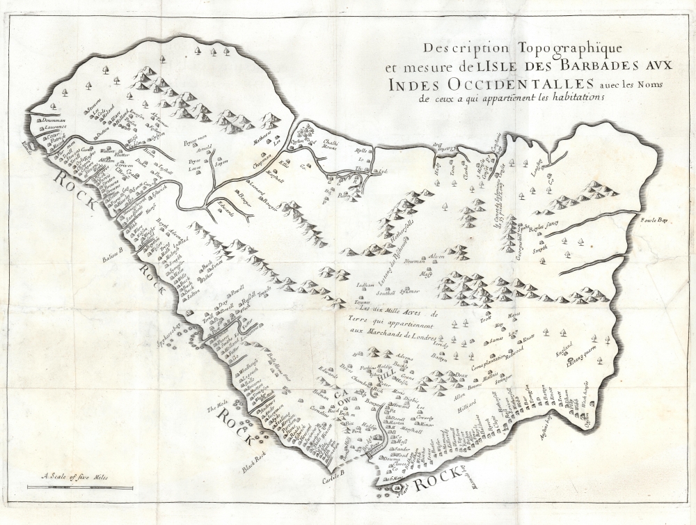
Description Topographique et mesure de LIsle des Barbades aux Indes Occidentalles avec les Noms de ceux a qui appartienent leas habitations.
1674 (undated) 15 x 21 in (38.1 x 53.34 cm) 1 : 100000
1674 (undated) 15 x 21 in (38.1 x 53.34 cm) 1 : 100000
Description
This is the 1675 first French edition of the earliest specific map of Barbados during the Sugar Revolution. The map is based upon Richard Ligon's 1657 map, composed from information received in Barbados from Captain John Swan, the island's leading surveyor. Ligon compiled it in debtor's prison after returning to London from a 2-year stint as a planter in Barbados. The map is oriented to the east and offers fair accuracy despite exaggerating the island's length by roughly a third. The map identifies numerous plantations throughout by name, as well as the beginnings of Bridgetown as 'Bridge'. In the middle of the map, a notation references the land leased by James Hay, 1st Earl of Carlisle (c. 1580 - 1636) to a group of merchants after Charles I rescinded the original grant of the island to Sir William Courteen (1572 - 1636).
The Sugar Revolution
This map reflects the island in the midst of the Sugar Revolution. In the mid-1600s, increasing demand for rum and sugar in Europe led elite European planters to develop a plantation system on Barbados that focused on maximum profit at the price of maximum social cost. The Barbadian plantation system was run on a system of indenture and chattel slavery, largely reliant on African slaves. As wealth and power concentrated into the hands of plantation owners, small mostly white-owned farms were bought out and consolidated into large estates. The small famers relocated to other islands, as well as to the North American colonies, specifically Carolina. The change in demographics had a long-term impact on the island, transforming the demographic from mostly independent European small-scale farmers in the early 17th century to a majority population of slaves and indentured servants by the second half of the century.Publication History and Census
This map is based upon an English map by Richard Ligon first published in London in 1657. The present example is from the 1674 French edition, for which it was wholly re-engraved without some of the more floridly decorative elements present on the English map. The engraver is unknown, but it may have been René Michault, who engraved several other maps for the French publication edited by H. Justel, Recueil De Divers Voyages Faits En Afrique et En l'Amerique. All examples are exceedingly rare. The book Recueil… occasionally comes to market priced well into 5 figures, but the last record we see for the separate map is in 2007.Cartographer
Richard Ligon (1585 - 1662) was an English businessman, author, polymath, and rake. Ligon was born into an elite royalist family, but lost his fortunes in the English Civil War (1642 - 1651). Ligon was 'the fourth son of a third son' and so inherited 'a respectable name but diluted fortune.' (Parker 39-40). Mired in debt and beset on all side by enemies, Ligon determined to make his fortune in the New World. In 1647, at 60 years of age, he left for the colony of Barbados, acquiring a half-share in a sugar plantation. After two years in the tropical climate, he acquired a persistent fever - likely malaria -, returning to England to recover. Back home, he was immediately arrested by his creditors. While in prison, he complied his notes from Barbados into an important work, A True and Exact History of the Island of Barbadoes, featuring the first specific map of that island. The work was popular, and published in 1657 and again in 1673, before being translated into French for a 1674 edition. The work provides a valuable first-person perspective on the Caribbean sugar trade, the early days of the Sugar Revolution, and 17th century European life in the West Indies. More by this mapmaker...
Source
Justel, H., Recueil De Divers Voyages Faits En Afrique et En l'Amerique , Qui N'ont Point Este Encore Publiez; Contenant L'origine, Les Moeurs, Les Coutumes et Le Commerce Des Habitans De Ces Deux Parties Du Monde, (Paris: Louis Billaine) 1674.
Condition
Good. Margin reinstated at top and at insertion point on upper right hand; mended tears into printed area with no loss of image. Else very good.
References
OCLC 494842419. Bibliothèque Nationale de France, GE BB-565 (14,103). Huntington Library, #280365.