
Lindenkohl, Adolph

Adolph Lindenkohl (March 6, 1833 – June 22, 1904) was a German-American cartographer and draughtsman active in the United States during the second part of the 19th century. Lindenkohl was born in Niederkaufungen, Hesse Cassel, Germany. He was educated at the Realschule and later at the Poytechnische Schule, both in Cassel. After graduating in 1852 he emigrated to the United States where, for 2 years, he taught mathematics before taking a position with the United States Coast Survey. Lindenkhol served as a topographer in the Union Army during the American Civil War, translating Coast Survey methodology and technique to land-side surveys for military use. This experience he later translated to other projects, such as the compilation of the first specific map of Alaska as part of the United States (1867). Lindenkohl was a member of the American Association for the Advancement of Science, the Washington Academy of Sciences, the Philosophical Society of Washington and the National Geographic Society. He retained his position with the Coast Survey until his death in 1904.
The Potomac River during the American Civil War.
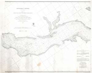
Potomac River (in four sheets) Sheet No. 2 From Piney Point to Lower Cedar Point.
$500.00
Acquire
- Digital Map Information
- Suitable for large format printing
- File Size: 21.56 MB
- File Type: ZIP / TIFF
- ICC color profile embedded
- Delivered instantly via download link
This is an 1862 U.S. Coast Survey nautical chart or maritime map of part of the Potomac River. Separating Maryland and Virginia, the map depicts from Lower Cedar Point to Piney Point. Depth soundings are indicated throughout, including in St. Clement's Bay and Breton's Bay. Points and other coastal features, including the Nomini Cliffs, are labeled. Navigational aids, such as buoys and lights, are illustrated and labeled, along with navigational hazards, including shoals and islands. (more details)