
Maire, Francois Joseph

François Joseph Maire (1738 - c. 1800) was a French cartographer, hydrographer, and military engineer based in Vienna and active during the mid- to late-18th century. Believed to have been born one Lorraine in France, Maire published numerous maps and is particularly known for maps made during the Russo-Turkish War of 1787 - 1792, which took place at the same time as the Austro-Turkish War.
Published during the Austro-Turkish War.
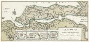
Helespont ou Detroit de Dardanelles pour servir de renseignement à la Carte des Limites des trois Empires ou Théatre de la Guerre.
$950.00
Acquire
- Digital Map Information
- Suitable for large format printing
- DPI: 600
- File Size: 23.13 MB
- File Type: ZIP / TIFF
- ICC color profile embedded
- Delivered instantly via download link
This is a 1788 François Joseph Maire map of the Dardanelles or the Hellespont in Turkey. A strait that forms a part of the boundary between Europe and Asia, separating Asian Turkey from European Turkey, the map depicts the Dardanelles from the east with the Gallipoli peninsula at center. Cities and towns are labeled all along the coast of the Strait, with particular attention paid to Gallipoli (now called Gelibolu). Topography is illustrated and Mount Ida is labeled. (more details)