1788 Maire Map of the Dardanelles or the Hellespont, Turkey
Helespont-maire-1788$950.00

Title
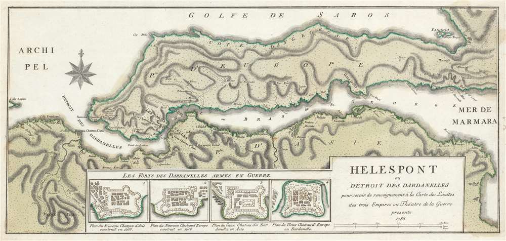
Helespont ou Detroit de Dardanelles pour servir de renseignement à la Carte des Limites des trois Empires ou Théatre de la Guerre.
1788 (dated) 12 x 25.25 in (30.48 x 64.135 cm) 1 : 160000
1788 (dated) 12 x 25.25 in (30.48 x 64.135 cm) 1 : 160000
Description
This is a 1788 François Joseph Maire map of the Dardanelles or the Hellespont in Turkey. A strait that forms a part of the boundary between Europe and Asia, separating Asian Turkey from European Turkey, the map depicts the Dardanelles from the east with the Gallipoli peninsula at center. Cities and towns are labeled all along the coast of the Strait, with particular attention paid to Gallipoli (now called Gelibolu). Topography is illustrated and Mount Ida is labeled.
A War Map?
Even though this map was created during the Austro-Turkish War of 1788 - 1791, which was part of the larger Russo-Turkish War of 1787 - 1792, no fighting took place in the region during the conflict. It is evident, however, why a military engineer based in Vienna would create such a map when their empire is fighting the Ottoman Empire. The Dardanelles had been considered a strategic location since Antiquity, when the region was known as the Hellespont. Here, Maire includes plans of the four forts strategically located along the Dardanelles. Two of these forts, labeled the 'new' forts of Asia and Europe respectively, were constructed in 1658 at the mouth of the Strait. The two 'old' forts that he details are situated further up the Strait at what appears to be the narrowest point, offering these fortresses a distinct strategic advantage. Although no fighting occurred here during this war, major actions would take place here during the Crimean War (1853 - 1856), World War I (1914 - 1919), and the Greco-Turkish War (1919 - 1922). It is worth noting that yet another Turkish fortress is identified in the upper right quadrant on the island of Panagia.Publication History and Census
This map was created by François Joseph Maire and published in 1788. The OCLC records examples as being part of the collections at the Bavarian State Library in Munich, Harvard University, the Library of the University of Bern, the National Library of Poland, and the British Library. We have traced only a handful of known occurrences when this map has entered the private market.Cartographer
François Joseph Maire (1738 - c. 1800) was a French cartographer, hydrographer, and military engineer based in Vienna and active during the mid- to late-18th century. Believed to have been born one Lorraine in France, Maire published numerous maps and is particularly known for maps made during the Russo-Turkish War of 1787 - 1792, which took place at the same time as the Austro-Turkish War. More by this mapmaker...
Condition
Very good. Even overall toning. Closed margin tears professionally repaired on verso. Blank on verso.
References
OCLC 899872290.