
Mayer, Tobias

Tobias Mayer (February 17, 1723 - February 20, 1762) was a German astronomer and cartographer famous for his studies of the Moon. He was born in Marbach, Germany and raised in Esslingen in poverty. Between 1744 and 1746, Mayer studied engraving in Augsburg under Andreas Silbereisen (1713 - 1751). Moving to Nuremberg, he began working for the Homann Heirs company in 1746. There, he showed outstanding prowess and introduced many improvements to cartography. For example, Mayer composed Mappa Critica, which illustrated the accuracy, or rather lack thereof, of the latitudes and longitudes of locations in Germany. The map showed three Germanies according to three different cartographers, de l'Isle, Homann, and himself. 'The latitudes of the cities was mostly consistent, whereas the longitudes of some places (such as Dresden or Prague) differed by as much as a degree, thus showing to what extent longitude was problematic even on land' (Wepster, Steven, Between Theory and Observations: Tobias Mayer's Explorations of Lunar Motion, 1751-1755, Berlin, 2009). Mayer went on to create some of the first charts of the Moon and his chart of the full moon was unsurpassed for half a century. His fame comes from his lunar tables, and thanks to his scientific reputation he was elected as the chair of economy and mathematics at the University of Göttingen in 1751. He became superintendent of the observatory in 1754, where he worked until his death in 1762. Mayer is occasionally erroneously referred to as 'the Elder' or 'Johann Tobias the Elder.'
Detailing a Projected Lunar Eclipse.
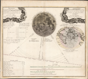
Vorstellung der in der Nacht zwischen den 8. u. 9. Aug. 1748 vorfallenden partialen Mond-Finsternis/ Représentation de l'Eclipse partiale de la Lune, qui arrivera la nuit du 8 au 9 d'Août, 1748.
$1,500.00
Acquire
- Digital Map Information
- Suitable for large format printing
- File Size: 25.94 MB
- File Type: ZIP / TIFF
- ICC color profile embedded
- Delivered instantly via download link
This is Tobias Mayer's 1748 celestial chart projecting the partial lunar eclipse of August 8 and 9, 1748. Published by the Nuremberg map printing house of Homann Heirs, this bilingual chart detailed the phases of the eclipse and the parts of the world from which the event would be visible. (more details)
A little known region mapped.
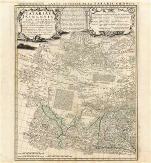
Tartariae Sinensis mappa Geographica...
$750.00
Acquire
- Digital Map Information
- Suitable for large format printing
- Full resolution TIFF file
- ICC color profile embedded
- Delivered instantly via download link
This is a handsome 1749 Homann Heirs map of western China, Mongolia and the extreme southeastern border with Russia. It was produced in order to accompany a German translation of P. Du Halde's 1732 Description de la Chine. As such, it is a faithful copy of J. B. D'Anville's Carte Generale de la Tartarie Chinoise which accompanied Du Halde's original text and the definitive mapping of this little-known and ill-mapped region. D'Anville's map - and Du Halde's data - were derived from Jesuit sources. Jesuits, with the blessing of the Qing Emperor Kangxi, produced at a map of the Chinese Empire's frontiers between 1708 and 1717. (more details)