1749 Homann Heirs Map of Chinese Tartary
TartariaeSinensis-hmhr-1749$750.00

Title
Tartariae Sinensis mappa Geographica...
1749 (dated) 19.75 x 15.75 in (50.165 x 40.005 cm) 1 : 5100000
1749 (dated) 19.75 x 15.75 in (50.165 x 40.005 cm) 1 : 5100000
Description
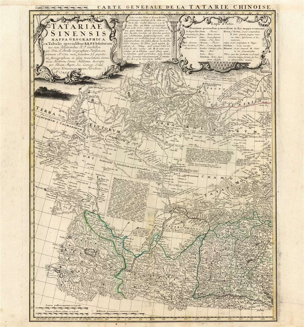
This is a handsome 1749 Homann Heirs map of western China, Mongolia and the extreme southeastern border with Russia. It was produced in order to accompany a German translation of P. Du Halde's 1732 Description de la Chine. As such, it is a faithful copy of J. B. D'Anville's Carte Generale de la Tartarie Chinoise which accompanied Du Halde's original text and the definitive mapping of this little-known and ill-mapped region. D'Anville's map - and Du Halde's data - were derived from Jesuit sources. Jesuits, with the blessing of the Qing Emperor Kangxi, produced at a map of the Chinese Empire's frontiers between 1708 and 1717.
The Scope of The Map
Starting from approximately 33 degrees north, the sheet shows in the south the Chinese regions of Qinghai, Gansu, and Shaanxi. The northern part of the map shows the Russian frontier up to the Onon River. Mongolia and the Gobi Desert lie between. The superbly engraved map includes detailed river networks, pictorially rendered mountains, and numerous caravan routes. There is an extensive descriptive text pertaining to the Gobi Desert, and the speculative location of the ancient capital of the Mongol Empire is noted - 'Terra Kalkarum.' D'Anville's cartography also identifies the ruins of various temples and palaces in Tartary. The map includes Lake Kokonor in the Qinghai Province of China, and embraces part of what is now the Xinjiang Uyghur Autonomous Region. The map is rich in place names and rivers, including several rivers disappearing into the endoheiric basins of the Gobi.Publication History and Census
This map was drawn - based on the D'Anville map - for the Homann Heirs firm by Tobias Mayer, and appears to have been a separate issue intended to accompany a German translation of Du Halde's Description de la Chine. It is usually part of a two-sheet map extending to the east and including Korea and Japan. We see nine examples listed in OCLC.CartographerS
Homann Heirs (1730 - 1848) were a map publishing house based in Nuremberg, Germany, in the middle to late 18th century. After the great mapmaker Johann Baptist Homann's (1664 - 1724) death, management of the firm passed to his son Johann Christoph Homann (1703 - 1730). J. C. Homann, perhaps realizing that he would not long survive his father, stipulated in his will that the company would be inherited by his two head managers, Johann Georg Ebersberger (1695 - 1760) and Johann Michael Franz (1700 - 1761), and that it would publish only under the name 'Homann Heirs'. This designation, in various forms (Homannsche Heirs, Heritiers de Homann, Lat Homannianos Herod, Homannschen Erben, etc..) appears on maps from about 1731 onwards. The firm continued to publish maps in ever diminishing quantities until the death of its last owner, Christoph Franz Fembo (1781 - 1848). More by this mapmaker...
Jean Baptiste Bourguignon d'Anville (1697 - 1782) was perhaps the most important and prolific cartographer of the 18th century. D'Anville's passion for cartography manifested during his school years when he amused himself by composing maps for Latin texts. There is a preserved manuscript dating to 1712, Graecia Vetus, which may be his earliest surviving map - he was only 15 when he drew it. He would retain an interest in the cartography of antiquity throughout his long career and published numerous atlases to focusing on the ancient world. At twenty-two D'Anville, sponsored by the Duke of Orleans, was appointed Geographer to the King of France. As both a cartographer and a geographer, he instituted a reform in the general practice of cartography. Unlike most period cartographers, D'Anville did not rely exclusively on earlier maps to inform his work, rather he based his maps on intense study and research. His maps were thus the most accurate and comprehensive of his period - truly the first modern maps. Thomas Basset and Philip Porter write: "It was because of D'Anville's resolve to depict only those features which could be proven to be true that his maps are often said to represent a scientific reformation in cartography." (The Journal of African History, Vol. 32, No. 3 (1991), pp. 367-413). In 1754, when D'Anville turned 57 and had reached the height of his career, he was elected to the Academie des Inscriptions. Later, at 76, following the death of Philippe Buache, D'Anville was appointed to both of the coveted positions Buache held: Premier Geographe du Roi, and Adjoint-Geographer of the Academie des Sciences. During his long career D'Anville published some 211 maps as well as 78 treatises on geography. D'Anville's vast reference library, consisting of over 9000 volumes, was acquired by the French government in 1779 and became the basis of the Depot Geographique - though D'Anville retained physical possession his death in 1782. Remarkably almost all of D'Anville's maps were produced by his own hand. His published maps, most of which were engraved by Guillaume de la Haye, are known to be near exact reproductions of D'Anville' manuscripts. The borders as well as the decorative cartouche work present on many of his maps were produced by his brother Hubert-Francois Bourguignon Gravelot. The work of D'Anville thus marked a transitional point in the history of cartography and opened the way to the maps of English cartographers Cary, Thomson and Pinkerton in the early 19th century. Learn More...
Tobias Mayer (February 17, 1723 - February 20, 1762) was a German astronomer and cartographer famous for his studies of the Moon. He was born in Marbach, Germany and raised in Esslingen in poverty. Between 1744 and 1746, Mayer studied engraving in Augsburg under Andreas Silbereisen (1713 - 1751). Moving to Nuremberg, he began working for the Homann Heirs company in 1746. There, he showed outstanding prowess and introduced many improvements to cartography. For example, Mayer composed Mappa Critica, which illustrated the accuracy, or rather lack thereof, of the latitudes and longitudes of locations in Germany. The map showed three Germanies according to three different cartographers, de l'Isle, Homann, and himself. 'The latitudes of the cities was mostly consistent, whereas the longitudes of some places (such as Dresden or Prague) differed by as much as a degree, thus showing to what extent longitude was problematic even on land' (Wepster, Steven, Between Theory and Observations: Tobias Mayer's Explorations of Lunar Motion, 1751-1755, Berlin, 2009). Mayer went on to create some of the first charts of the Moon and his chart of the full moon was unsurpassed for half a century. His fame comes from his lunar tables, and thanks to his scientific reputation he was elected as the chair of economy and mathematics at the University of Göttingen in 1751. He became superintendent of the observatory in 1754, where he worked until his death in 1762. Mayer is occasionally erroneously referred to as 'the Elder' or 'Johann Tobias the Elder.' Learn More...
Condition
Very good. Top margin extended, title slightly trimmed. Original outline and wash color.
References
OCLC 1027785849.