
Mellis, Fred R.

Fred R. Mellis (November 1854 - June 28, 1922) was an Austrian-American real estate agent who was also involved in mining and insurance. Born in Austria, Mellis arrived in the United States in 1873. Mellis settled in eastern Oregon, eventually in Baker, where he worked in real estate and mining. Mellis was the president of the Oregon-Idaho Investment Company which dealt in mining property in southern Idaho and eastern Oregon. Mellis was involved in Oregon's displays at several world's fairs (including in Paris, St. Louis, and San Francisco). We have learned from newspaper articles that Mellis owned one of the finest collections of minerals in the Pacific Northwest around the turn of the 20th century. Per an article in the Oregon Daily Journal from September 13, 1919
Mellis has been accumulating gold specimens for 15 years in Baker and Grant counties, and has acquired a display regarded as the best private collection on the Pacific coast, and the best exhibit in the entire Northwest. It is on exhibition at the Bater Loan and Trust company bank here [in Baker, Oregon], and has long been a center of interest to mining men. Both free gold nuggets and quartz specimens are included in the collection.Mellis shipped his entire collection to the St. Louis World's Fair in 1904.
Boomtimes in Eastern Oregon.
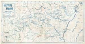
Eastern Oregon Mines, Timber, Grazing and Farming Land Tributary to Baker, Ore.
$1,200.00
Acquire
- Digital Map Information
- Suitable for large format printing
- File Size: 16.55 MB
- File Type: ZIP / TIFF
- ICC color profile embedded
- Delivered instantly via download link
This is a fascinating 1916 Fred R. Mellis map of eastern Oregon, capturing the height of an early 20th-century gold mining and logging boom. The map focuses on Baker, which was then emerging as the regional center of mining, timber, and agriculture. As a diazo (reverse blueprint), the map can only have been issued in small quantities, and its annotation of industry, transport networks, and electrical and irrigation networks suggests it was made for administrative use. (more details)