
Moisy, Alexandre

Alexandre Moisy (1763 - c. 1827), also known as Claude Alexandre Moisy, was a French engraver. Born in Paris, Moisy was a prolific engraver who worked on numerous projects, several of which were books. Some of the texts that he contributed engravings to include Voyage picturesque de la Syrie, de la Phénicie de la Palestine, et de la Base Égypte by Louis Françpis Cassas and published in 1799 and Les ruined de Paestum by Claude Mathieu Delagardette published in 1798. Moisy also engraved all the plates for the book entitled Les Fontaines de Paris, Anciennes et Nouvelles, for which he drew all the engravings and also served as the editor.
Highlights the European discovery, conquest, and exploration of the Americas.
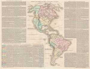
Amérique Historique, Physique et Politique Actuelle.
$300.00
Acquire
- Digital Map Information
- Suitable for large format printing
- DPI: 300
- File Size: 14.15 MB
- File Type: ZIP / TIFF
- ICC color profile embedded
- Delivered instantly via download link
This is a c. 1835 Emmanuel, Comte de Las Cases and Paul Renouard map of the Western Hemisphere. The map depicts the entirety of North, Central, and South America, along with the Caribbean Sea and part of the Pacific and Atlantic Oceans. The discovery, conquest, and ... (more details)
Features commentary on world affairs - including forms of government.
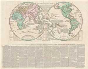
Mappemonde Historique.
$325.00
Acquire
- Digital Map Information
- Suitable for large format printing
- DPI: 300
- File Size: 13.11 MB
- File Type: ZIP / TIFF
- ICC color profile embedded
- Delivered instantly via download link
This is a c. 1835 Emmanuel, Comte de Las Cases and Paul Renouard map of the world in hemispheres. The map depicts both the Eastern and Western Hemispheres, with the hemispheres meeting in the middle of the Pacific Ocean near the Solomon Islands. Incredibly, though ... (more details)