1835 Las Cases (Lesage) and Renouard Map of the World in Hemispheres
Mappemonde-renouard-1827$325.00

Title
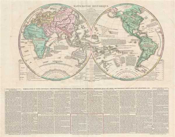
Mappemonde Historique.
1835 (undated) 19.25 x 24.75 in (48.895 x 62.865 cm) 1 : 72864000
1835 (undated) 19.25 x 24.75 in (48.895 x 62.865 cm) 1 : 72864000
Description
This is a c. 1835 Emmanuel, Comte de Las Cases and Paul Renouard map of the world in hemispheres. The map depicts both the Eastern and Western Hemispheres, with the hemispheres meeting in the middle of the Pacific Ocean near the Solomon Islands. Incredibly, though unconventionally, detailed, countries and regions around the world are labeled, though no political boundaries are illustrated. Notes are included throughout, usually stating what items / luxuries a certain country or region had 'given' to Europeans. Others describe parts of the world in detail, commenting on their politics (Asia as the 'Land of despotism' and Africa as the 'Land of servitude') or other aspects of that part of the world, particularly if there is a direct French connection. The 'approximate outline of the World known by the Ancients' is illustrated by a red line in the Eastern Hemisphere, encompassing Europe, North Africa, and Asia as far east as India. Around each hemisphere, Las Cases comments on different climatological regions, referring to the Arctic as 'region of excessive cold'. A graphic detailing the length of global rivers is situated at the lower left of the Eastern Hemisphere and an identical graphic concerning the elevation of the world's highest mountains is included at the lower right of the Western Hemisphere. A detailed text concerning exploration and certain aspects of the map is included below the two hemispheres.
This map was drawn by Emmanuel, Comte de Las Cases, engraved by Alexandre Moisy and the lettering was engraved by Jacques-Marie Hacq, the engraver of the Dépot de la Guerre and the Dépot de la Marine. It was published by Paul Renouard in Las Cases' Atlas historique c. 1835.
This map was drawn by Emmanuel, Comte de Las Cases, engraved by Alexandre Moisy and the lettering was engraved by Jacques-Marie Hacq, the engraver of the Dépot de la Guerre and the Dépot de la Marine. It was published by Paul Renouard in Las Cases' Atlas historique c. 1835.
CartographerS
Emmanuel-Augustin-Dieudonné-Joseph, comte de Las Cases (June 21, 1766 - May 15, 1842) was a French historian and atlas maker. Born at the family's castle near Revel in Languedoc, Las Cases was educated at military schools in Vendôme and Paris. He then entered the navy where he saw action during the years 1781-82. He was forced to flee France during the French Revolution, and spent several years in Germany and England. He took part in the Quiberon Expedition in 1795 (an invasion of France on the Quiberon peninsula by émigré ,counter-revolutionary troops in support of the Vendée Revolt) that was soundly defeated by the Republican army. Las Cases was one of the few to return to London alive. In 1801 he published the first edition of his Atlas Historique under the pseudonym A. Lesage. Upon his return to France after the Peace of Amiens in 1802, Las Cases published the first French edition of his atlas in 1803-1804 called the Atlas historique, généalogique, chronologique et géographique de A. Lesage. Las Casas returned to France during the Consulate and, with other royalists, rallied to the side of Napoleon Bonaparte. Las Cases would support Napoleon throughout his reign, and was eventually made a chamberlain and then a count of the empire. After the first abdication in 1814, Las Cases again fled to England, but returned to Napoleon's side during the Hundred Days. After the defeat at Waterloo, Las Cases was the one who suggested Napoleon throw himself at the mercy of the British Empire and later accompanied him to Saint Helena. It was on Saint Helena where Las Cases acted as Napoleon's secretary, taking detailed notes of their conversations. These notes were then published in book form following Napoleon's death as Le Mémorial de Sainte-Hélène, which is remembered as a less-than-neutral account of Napoleon's time on Saint Helena. More by this mapmaker...
Alexandre Moisy (1763 - c. 1827), also known as Claude Alexandre Moisy, was a French engraver. Born in Paris, Moisy was a prolific engraver who worked on numerous projects, several of which were books. Some of the texts that he contributed engravings to include Voyage picturesque de la Syrie, de la Phénicie de la Palestine, et de la Base Égypte by Louis Françpis Cassas and published in 1799 and Les ruined de Paestum by Claude Mathieu Delagardette published in 1798. Moisy also engraved all the plates for the book entitled Les Fontaines de Paris, Anciennes et Nouvelles, for which he drew all the engravings and also served as the editor. Learn More...
Paul Renouard (1803 - 1871) was a French printer and publisher. He was the third son of the famous Parisian bookseller Antoine-Augustin Renouard (1765 - 1853), and brother of publisher Jules Renouard (1798 - 1854). He was active in the book printing and publishing worked until 1849 when he retired and began a career in the foreign service in Asia. Learn More...
Source
Las Cases, E. Atlas historique, généalogique, chronologique, et géographique (Paris: Paul Renouard) 1827.
Originally published as the Geneaological, Chronological, Historical, and Geographical Atlas under the pseudonym A. Lesage by Emmanuel, Comte de Las Cases in 1801 during his exile from France caused by the French Revolution. Las Cases then published the first French edition, entitled Atlas historique, généalogique, chronologique, et géographique in 1803. Numerous subsequent editions were published in French, Russian, Italian, and German through approximately 1850.
Condition
Very good. Even overall toning. Verso repair to centerfold separation. Blank on verso.
References
OCLC 733693988.