
Monsarrat, Marcus Douglas

Marcus Douglas Monsarrat (March 29, 1857 - October 23, 1922) was a Hawaiian surveyor. Born in Honolulu, Monsarrat attended Oahu College and graduated in 1873. Monsarrat worked fro the Hawaiian Government Survey from around 1874 until 1877, when he opened his own surveying firm. Over the course of his career, Monsarrat surveyed and mapped a large portion of the Hawaiian Islands and served as crown surveyor from 1878 until Hawaii's annexation by the United States in 1898. He also served as the commissioner of boundaries between the first and second judicial circuits from 1902 until his death. He married Florence Ellen Luce on June 1, 1882, with whom he had three children. He and Florence later divorced.
Lanai's traditional Hawaiian land subdivisions.
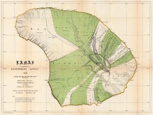
Lanai.
$850.00
Acquire
- Digital Map Information
- Suitable for large format printing
- File Size: 56.56 MB
- File Type: ZIP / TIFF
- ICC color profile embedded
- Delivered instantly via download link
This is the 1878 / 1906 Hawaiian Government Survey and Hawaiian Territorial Survey map of Lanai, Hawaiian Islands. Jacob Brown and Marcus Monsarrat produced this detailed survey of Lanai in 1878, publishing at that time the preliminary version of the present map, the first to correctly capture Lanai's form. Today Lanai is the smallest publicly accessible inhabited island. Here, Lanai's ahupua'a, traditional land subdivisions, stretch across the island. The few roads are illustrated, along with a handful of foot trails. (more details)