1906 Hawaiian Government Survey Map of Lanai, Hawaiian Islands
Lanai-govtsurvey-1906$850.00

Title
Lanai.
1906 (dated) 20 x 26.5 in (50.8 x 67.31 cm) 1 : 48000
1906 (dated) 20 x 26.5 in (50.8 x 67.31 cm) 1 : 48000
Description
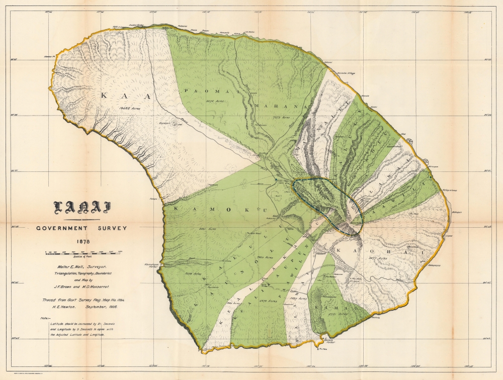
This is the 1878 / 1906 Hawaiian Government Survey and Hawaiian Territorial Survey map of Lanai, Hawaiian Islands. Jacob Brown and Marcus Monsarrat produced this detailed survey of Lanai in 1878, publishing at that time the preliminary version of the present map, the first to correctly capture Lanai's form. Today Lanai is the smallest publicly accessible inhabited island. Here, Lanai's ahupua'a, traditional land subdivisions, stretch across the island. The few roads are illustrated, along with a handful of foot trails.
Publication History and Census
This map was traced by H. E. Newton in September 1906 for inclusion in the Annual Reports of the Department of the Interior for the Fiscal Year Ended June 30, 1906 from a map created by Jacob F. Brown and Marcus D. Monsarrat in 1878. We note seven examples cataloged in OCLC which are part of the collections at the Library of Congress, Michigan State University, the University of Texas at Arlington, Brigham Young University, the University of California San Diego, the University of California Davis, and the University of California Berkeley.CartographerS
Walter Eugene Wall (October 13, 1867 - July 23, 1944) was an American surveyor. Born in Yreka, California, he arrived in Honolulu with his parents in 1880. His father was the architect in charge of the construction of the Iolani Palace. He began working at the Hawaiian Government Survey in 1889 and was appointed Territorial Surveyor General in 1901. He worked for the survey for more than 35 years. Wall attended the Ponahou School where he was known for his athletics, introducing the curveball (referenced as 'curve pitching in baseball' in his obituary) to Hawaii. He married Edith Louise Dietz on June 22, 1903. He died in 1944 in Honolulu. More by this mapmaker...
Andrew B. Graham (1845 - September 9, 1909) was an American lithographer active in Washington, D.C. in late 19th and early 20th century. Graham was born in Washington D.C., the son of a lithographer and engraver. After college, he joined the U.S. Coast Survey, where he was a draftsman until 1889. He retired from the Coast Survey to take over management of his father's lithography firm. The firm, Andrew B. Graham Company, was one of several that thrived on lucrative government publication contracts. Graham died of 'brain fever' in his Washington D. C. residence on September 9 of 1909. Some of his work was republished posthumously until about 1917, and his firm was active until at least the early 1920s. Learn More...
Marcus Douglas Monsarrat (March 29, 1857 - October 23, 1922) was a Hawaiian surveyor. Born in Honolulu, Monsarrat attended Oahu College and graduated in 1873. Monsarrat worked fro the Hawaiian Government Survey from around 1874 until 1877, when he opened his own surveying firm. Over the course of his career, Monsarrat surveyed and mapped a large portion of the Hawaiian Islands and served as crown surveyor from 1878 until Hawaii's annexation by the United States in 1898. He also served as the commissioner of boundaries between the first and second judicial circuits from 1902 until his death. He married Florence Ellen Luce on June 1, 1882, with whom he had three children. He and Florence later divorced. Learn More...
Jacob Foster Brown (July 9, 1854 - January 4, 1925) was an American engineer and surveyor. Born in New Bedford, Massachusetts, Brown arrived in Hawaii at the age of six after his father accepted a job with the Hawaiian government. Brown began working for W. D. Alexander in the late 1860s or early 1870s before attending the Massachusetts Institute of Technology from 1874 - 1877, earning a degree in civil engineering. He served as assistant surveyor-general of Hawaii from 1874 until 1895. In 1885, Brown was appointed to supervise the survey of government lands that would be distributed under the 1884 Homestead Act. He served as land commissioner from November 1895 until May 1901. He married Sarah Emily King on January 18, 1881. Learn More...
Source
Governor of Hawaii Board of Indian Commissioners, 'Report of the Governor of Hawaii', Annual Reports of the Department of the Interior for the Fiscal Year Ended June 30, 1906, (Washington: Government Printing Office) 1907.
Condition
Good. Wear and toning along original fold lines. Light soiling. Closed margin tear professionally repaired on verso.
References
Moffat, R. M. and G. L. Fitzpatrick, Mapping the Lands and Waters of Hawaii (Honolulu: Editions Limited) 2004 p. 59. OCLC 367573432.