
Neuman and Dinglinger Lithography

Neuman and Dinglinger Lithography (fl. 1880 - 1882) was a New York City based lithography and engraving firm based at the Northwest corner of Pearl and Elm Streets, New York City. Little is known of their business. They published an important chronological chart of American history, as well as maps for James Botsford Beers (1811 - 1901) and John Bute Holmes (1822 - 1887). In addition to maps, they also produced stunning chromolithograph trade cards for the tobacco industry. Most of their work dates to the early 1880s.
Includes part of Bloomingdale Road, today known as Broadway, including Times Square.
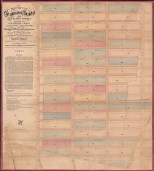
Map of the Common Lands from 42nd to 59th Streets Showing the Old Streets and Plots…
$3,000.00
Acquire
- Digital Map Information
- Suitable for large format printing
- File Size: 29.23 MB
- File Type: ZIP / TIFF
- ICC color profile embedded
- Delivered instantly via download link
This is a John Bute Holmes 1874 cadastral map of Midtown Manhattan. The map depicts the region from Seventh Avenue to Third Avenue and from 59th Street to 42nd Street. A somewhat-confusing jumble of solid and dashed lines appears throughout the neighborhood, allowing the viewer to trace its development, particularly with regard to streets. Entire blocks were shifted between 1796, when Goerck first surveyed this part of Manhattan, and 1874, when Holmes created this work. Street angles changed, as did the width of both the streets and the avenues.
Albany Avenue, Steuben Street Cross Road, and the Eastern Post Road (also known as the Boston Post Road) were erased when the grid system was implemented. Bloomingdale Road, in the lower left corner, is known as Broadway today, thus illustrating the intersection of 42nd Street and Broadway, Times Square. At some point after Goerck's initial survey, both Madison Avenue and Lexington Avenue were cut down the middle of the blocks between Fourth Avenue and Fifth Avenue, and Fourth and Third Avenue, respectively, evident by how Holmes identifies each block by only one number and not two. (more details)
Albany Avenue, Steuben Street Cross Road, and the Eastern Post Road (also known as the Boston Post Road) were erased when the grid system was implemented. Bloomingdale Road, in the lower left corner, is known as Broadway today, thus illustrating the intersection of 42nd Street and Broadway, Times Square. At some point after Goerck's initial survey, both Madison Avenue and Lexington Avenue were cut down the middle of the blocks between Fourth Avenue and Fifth Avenue, and Fourth and Third Avenue, respectively, evident by how Holmes identifies each block by only one number and not two. (more details)
One of the earliest specific maps of the Lower East Side!
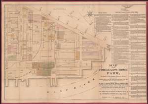
Map of the Corlear's Hook Farm, Situated in the present Seventh Ward…
$3,000.00
Acquire
- Digital Map Information
- Suitable for large format printing
- Full resolution TIFF file
- ICC color profile embedded
- Delivered instantly via download link
This is a rare 1881 Heinrich Windwart map of the New York City's Lower East Side, from Grand Street to the East River and from Montgomery to East Street, a region once known as the Corlear's Hook Farm. This is most likely the earliest specific published map of this part of New York. The meticulously compiled map illustrates multiple estates, including those of Nicholas Romayne, Nicholas Gouverneur, James Blanchard, Nicholas Cruger, Nicholas Low, Edward Laight, Stringham, Quackenbos, McComb, Roome, Willima Low, and the Gardner state. It illustrates the original waterline of Manhattan before the mid-19th century landfills. In addition, it shows underwater lands belonging to the Corporation of New York according to the legislative act of 1871. (more details)