
Pacific Railroad Surveys

The Pacific Railroad Surveys (1853 - 1855) were established in 1853 with the goal of identifying the best possible routes for a transcontinental railroad from the Mississippi to the Pacific. The need for transcontinental railroad made itself evident shortly after the California Gold rush when the westward expansion was at its heights. The federal government, acting under the Sectary of War, Jefferson Davis (of Civil War fame), initiated a series of expeditions of the western territories. These expeditions included surveyors, cartographers, artists, zoologists, botanists and geographers. The resultant work, a 12 volume compendium entitled Reports of Explorations and Surveys, to ascertain the most practicable and economical route for a railroad from the Mississippi River to the Pacific Ocean eventually led to the constructions of several different transcontinental railroads.
Perhaps the first American depiction of Mt. Shasta.
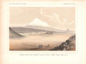
Shasta Butte and Shasta Valley From A Point Near Camp 70 A.
$125.00
Acquire
- Digital Map Information
- Suitable for large format printing
- File Size: 12.75 MB
- File Type: ZIP / TIFF
- ICC color profile embedded
- Delivered instantly via download link
This is an 1855 view of Mt. Shasta and the Shasta River Valley in northern California, near the border with Oregon. The view was made by agents of the Pacific Railroad Surveys, an important precursor to the Transcontinental Railroad and also a great storehouse of research material about the environment and peoples of the American West just after these areas were incorporated into or conquered by the United States. (more details)
An early view of Mt. Jefferson in the Cascade Range.
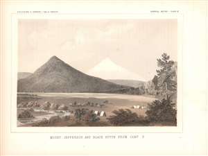
Mount Jefferson and Black Butte from Camp S.
$125.00
Acquire
- Digital Map Information
- Suitable for large format printing
- File Size: 11.83 MB
- File Type: ZIP / TIFF
- ICC color profile embedded
- Delivered instantly via download link
This is an 1857 view of Mt. Jefferson, a stratovolcano and the second highest peak in Oregon, and Black Butte, a smaller extinct stratovolcano twenty-one miles to the southeast of Mt. Jefferson. The two peaks are part of the Cascade Range and sit within the Willamette and Deschutes National Forests. The view was produced for the Pacific Railroad Surveys, an important precursor to the Transcontinental Railroad and also a great storehouse of research material about the environment and peoples of the American West just after these areas were incorporated into or conquered by the United States. (more details)