
Purdy, Isaac 2

Isaac Purdy 2 (fl. c. 1840 - 1869) was an English engraver and publisher of Blueback nautical charts active in the middle part of the 19th century. Purdy is presumed to be grand-nephew of the earlier generation map publisher John Purdy (1773 - 1843). He was active until at least 1869, possibly later, and should not be confused with the Admiralty Hydrography Isaac Purdy 1 (1804 - 1852).
Azores - the key the North Atlantic.
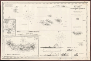
Laurie's Chart of the Azores or Western Islands.
$1,200.00
Acquire
- Digital Map Information
- Suitable for large format printing
- File Size: 2158.46 MB
- File Type: ZIP / TIFF
- ICC color profile embedded
- Delivered instantly via download link
An impressive 1859 blueback nautical map of the Azores and surrounding waters, drawn by Isaac Purdy, based on surveys by Captain A.T.E. Vidal, and published by Richard H. Laurie. This work represents the premier nautical chart of the Azores in the mid-19th century. (more details)