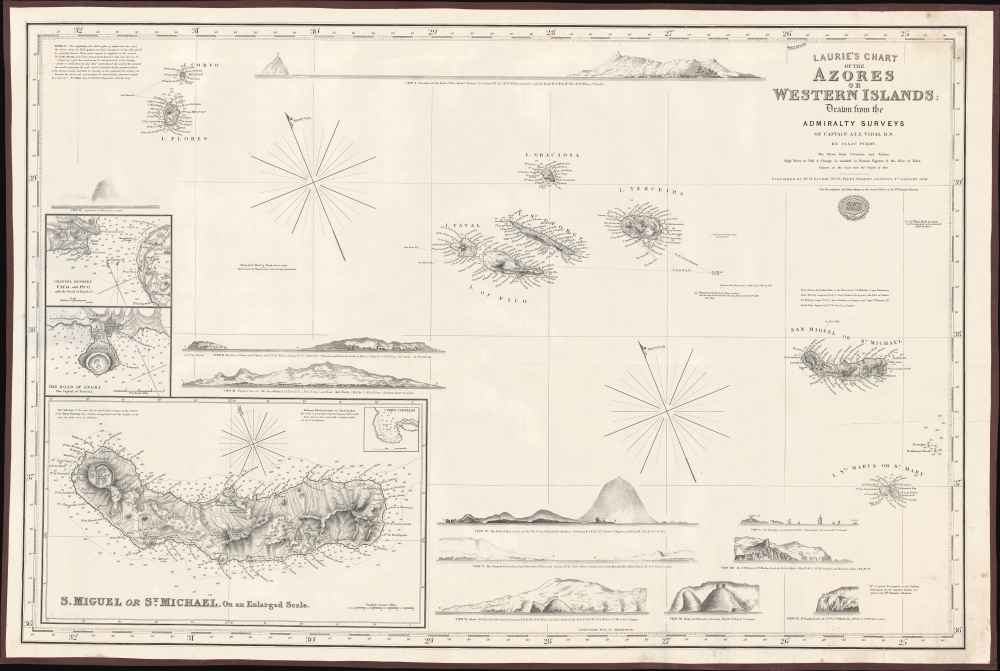
1859 Purdy / Vidal Chart of the Azores, Portugal
Azores-purdy-1859
Title
1859 (dated) 37 x 24.5 in (93.98 x 62.23 cm)
Description
A Closer Look
The islands of the Azores are covered in their entirety, with elevation and other topographic details illustrated and elevation noted at peaks. Along their coasts, soundings, hazards, shoals, and other features are indicated, along with some outcroppings further afield, including a volcano and 'Whale Rock' just below the title. Compass roses with magnetic variations and a text block discussing winds at top-left further assist the navigator. Three inset maps appear at bottom-left, detailing the channel between Fayal and Pico, the Road of Angra, the capital and largest city on the island of Terceira, and S. Miguel or St. Michael, the largest of the eastern Azores. Eleven profile views surround the chart, the location from which they were drawn being recorded on the chart.A note below the title refers to directions which can be found in the North Atlantic Memoir (Memoir, descriptive and explanatory, of the northern Atlantic Ocean). Although by this time the Azores were no longer a colonial testing ground for Portugal, they retained their importance for navigation and as a stopping point in the North Atlantic for transatlantic voyages. As an indication of their continued significance, during World War II (1939 - 1945) the Allies contemplated seizing the island chain from neutral Portugal to use its airfields to protect Allied convoys being harassed by German U-boats. However, Portugal agreed to let the Allies use the airfields and an occupation was unnecessary.
Blueback Charts
Blueback nautical charts began appearing in London in the late 18th century. Bluebacks, as they came to be called, were privately published large format nautical charts known for their distinctive blue paper backing. The backing, a commonly available blue manila paper traditionally used by publishers to wrap unbound pamphlets, was adopted as a practical way to reinforce the low-quality paper used by private chart publishers in an effort to cut costs. That being said, not all blueback charts are literally backed with blue paper. The earliest known blueback charts include a 1760 chart issued by Mount and Page, and a 1787 chart issued by Robert Sayer.The tradition took off in the early 19th century, when British publishers like John Hamilton Moore, Robert Blachford, James Imray, William Heather, John William Norie, Charles Wilson, David Steel, R. H. Laurie, and John Hobbs, among others, rose to dominate the chart trade. Bluebacks became so popular that the convention was embraced by chartmakers outside of England, including Americans Edmund March Blunt and George Eldridge, as well as Scandinavian, French, German, Russian, and Spanish chartmakers. Blueback charts remained popular until the late 19th century, when government subsidized organizations like the British Admiralty Hydrographic Office and the United States Coast Survey began issuing their own superior charts on high quality paper that did not require reinforcement.
Publication History and Census
This nautical chart was drawn by Isaac Purdy based on surveys by A.T.E. Vidal and published by Richard Laurie in 1859. It is not listed in the OCLC and its only known institutional holding is with the Museu Marítim de Barcelona.CartographerS
Isaac Purdy 2 (fl. c. 1840 - 1869) was an English engraver and publisher of Blueback nautical charts active in the middle part of the 19th century. Purdy is presumed to be grand-nephew of the earlier generation map publisher John Purdy (1773 - 1843). He was active until at least 1869, possibly later, and should not be confused with the Admiralty Hydrography Isaac Purdy 1 (1804 - 1852). More by this mapmaker...
Vice Admiral Alexander Thomas Emeric Vidal (1792- 5 February 1863) was an officer of the Royal Navy and an accomplished surveyor. Vidal, the youngest of four children, followed his father into the Navy. He began his naval career in December 1803, at the age of 11, as a 1st class volunteer. He served until 1805 when he joined the Royal Naval College at Portsmouth. He was assigned to the HMS Lavinia and spent three years aboard as a midshipman. He received his first commission in 1815 and was appointed to HMS Leven in 1818 as a first lieutenant under William Fitzwilliam Owen. Vidal accompanied Owen on his voyage to Africa to map the eastern coast. Vidal received his first command in May 1823, while one the expedition with Owen, that of HMS Barracuda.
Vidal spent most of his career as a surveyor, who was charged with several tasks, including locating Aitken’s Rock, a rock supposedly in the North Atlantic. There were at least seven different reports of the potential hazard, stating that it was small and protruded only about four feet from the surface of the ocean. In 1830, Vidal was dispatched to find the rock and accurately chart its location. After six weeks of charting supposed locations, Vidal was unable to locate it. However, during the hunt for Aitken’s Rock, Vidal successfully discovered and charted Vidal bank, and the following year was the first to accurately chart and describe Rockall, a nearly 60 foot high islet in the North Atlantic. The United Kingdom claimed the islet in his name in 1955. Learn More...
Richard Holmes Laurie (December 2, 1777 - January 19, 1858) was a British map and chart publisher and seller. Born in London to publisher Robert Laurie and his wife Esther Jouret, R. H. Laurie took over his father's share of the Laurie and Whittle publishing firm upon his father's retirement in 1812 and began trading as Whittle and Laurie. After Whittle died in 1818, Laurie continued the business by himself, trading under the imprint R. H. Laurie. During the 1820s and 1830s, Laurie expanded the nautical chart business until he was overtaken by Admiralty charts. Laurie married Susan Ann Coates on February 6, 1814 and later married Mary Ann Dennison on October 15, 1833. He left his business and all his property in trust for his two surviving daughters (both of whom were minors) with his principal engraver, Alexander George Findlay. Findlay continued the business in Laurie's name after acquiring its equity from his daughters. Learn More...


