
Robijn, Jacobus

Jacobus Robijn (1649 - c. 1707) was a Dutch mapmaker, engraver, colorist, and publisher. He was born in Amsterdam; little is known of his youth. By 1673, he was known as a map colorist. Sometime between then and 1693 he opened his own publishing house, also selling astronomical and navigational instruments. In the course of his business, beyond the normal practice of updating and republishing existing maps, he was found guilty of violating other mapmakers' privileges. After having acquired his own privilege, he would, in turn, suffer from others copying and selling his maps. Robijn also worked alongside other map and chartmakers; he collaborated with Johannes van Keulen on at least twenty-six charts.
Bold, detailed rarity of Spain and Portugal.
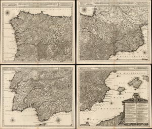
Novissima, et Accuratissima Tabula, qua Gallaeciae et Legionis Regna, Asturiarum Principatus. Portugalliae Tractus Septentrionalis et Utriusque Castellae, Extremadurae et Biscajae Partes./ ... Regnorum Arragoniae et Navarre, Principatus Cataloniae, nec non Partium con Conterminarum, Biscajae Utriusque Castellae ac Valentiae./ ... Regnorum Vandalitiae, Granatae, et Algarbiae; Tractuum, Meridionalium Portugalliae Extremadurae ac Castellae Novae./... Regnorum Valentiae et Murciae, Insularum Majorcae, Minorcae, et Ivicae qua etiam Vicinorum Regnorum Finitime Partes.
$8,500.00
Acquire
- Digital Map Information
- Suitable for large format printing
- Full resolution TIFF file
- ICC color profile embedded
- Delivered instantly via download link
This is a superb, rare example of Joachim Ottens' large, beautifully engraved c. 1719 four-sheet map of Spain and Portugal that notably references battles during the War of the Spanish Succession (1701 - 1714). The map was printed to four sheets for inclusion in folio atlases, but could be joined together to make a wall map. The plates had a convoluted, yet narrow publication history; any state of this map is a rare find. (more details)