
1700 / 1719 Joachim Ottens Four-Sheet Map of Spain and Portugal

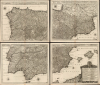
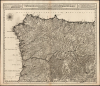
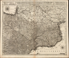
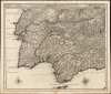
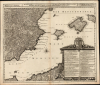
Novissima, et Accuratissima Tabula, qua Gallaeciae et Legionis Regna, Asturiarum Principatus. Portugalliae Tractus Septentrionalis et Utriusque Castellae, Extremadurae et Biscajae Partes./ ... Regnorum Arragoniae et Navarre, Principatus Cataloniae, nec non Partium con Conterminarum, Biscajae Utriusque Castellae ac Valentiae./ ... Regnorum Vandalitiae, Granatae, et Algarbiae; Tractuum, Meridionalium Portugalliae Extremadurae ac Castellae Novae./... Regnorum Valentiae et Murciae, Insularum Majorcae, Minorcae, et Ivicae qua etiam Vicinorum Regnorum Finitime Partes.
Bold, detailed rarity of Spain and Portugal.
- Digital Map Information
- Suitable for large format printing
- Full resolution TIFF file
- ICC color profile embedded
- Delivered instantly via download link
Bold, detailed rarity of Spain and Portugal.
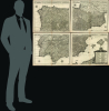
This is a superb, rare example of Joachim Ottens' large, beautifully engraved c. 1719 four-sheet map of Spain and Portugal that notably references battles during the War of the Spanish Succession (1701 - 1714). The map was printed to four sheets for inclusion in folio atlases, but could be joined together to make a wall map. The plates had a convoluted, yet narrow publication history; any state of this map is a rare find.A Closer Look
The map's four sheets, taken together, cover the entire Iberian Peninsula. The northeastern sheet includes a significant portion of France, reaching into the Languedoc and as far north as Gascony (including the cities of Nérac and Cahors). The southeastern sheet includes the Balearic Islands: Majorca, Minorca, and Ibiça. Along the southern edge is part of the Barbary Coast of Africa. The lower right corner is embellished with a beautiful, fruit-garlanded cartouche surmounted by the coat of arms of King Charles II of Spain (1661 - 1700). The cartouche contains tables, presented in French and Dutch, detailing the individual kingdoms within Spain and Portugal, enumerating their capitals and dioceses. Each sheet has a title border at the top, which also contains the map's scales and a legend explaining the map's symbols. These identify cities and towns, the presence of bishoprics and archbishoprics, academies, forts, and roads. The map itself shows topography pictorially. Roads and rivers are marked out in remarkable detail. Coastlines include depth soundings and anchorages in many places. Battles noted include the Battle of Vigo Bay (1702), the Siege of Gibraltar (1704), and the Siege of Barcelona (1705). While sparing in decorative embellishment, the map sports six elegant compass roses.Revisions and History
The plates were engraved by Luggert van Anse, whose hand was active on them throughout most of their publication history. The earliest states of the map correspond to those printed by Jacob Robijn; these are typically dated between 1690 and 1696, which is an impossibility, since the map includes features tied directly to the War of the Spanish Succession (1701 - 1714), in particular the Battle of Vigo Bay (October 23, 1702). Van Anse's dramatic mapping of Vigo Bay was modeled directly on Pierre Mortier's broadsheet map of the battle. While van Anse may have begun work on the map earlier, there is no known example that could have been printed before the end of 1702. We are aware of a Robijn proof state of the lower-right sheet that lacks a cartouche, and a Robijn state with an elaborate cartouche, very different from the one present in later versions.The plates were then acquired by Carel Allard; he changed little geographically, retaining van Anse's imprint. The Allard state of the map keeps the 1702 Battle of Vigo Bay, but there is no indication of the 1704 Siege of Gibraltar, suggesting that Allard's acquisition of the plates occurred before that date. Visually, the great change under Allard was the addition of the armorial and floral cartouche that graces all later versions.
Van Anse seems to have either had possession of these plates throughout or retrieved them after Carel Allard's death in 1709. Whatever the case may be, there exists a version sold under van Anse's own imprint, here with significant updates and improvements. In the body of the map, van Anse filled open spaces with additional hills and forests; along the bottom of the fourth plate, he added the portion of the Barbary Coast of North Africa visible here. The map's six compass roses were added around this time. But his changes are not all cosmetic. The regions of New Castile and Extremadura have been significantly reworked, with cities moved - notably, the walled town of Coria has been moved as earlier states placed it too far to the north. On the Mediterranean coast, the region around Alicante, from Cartagena to Cap de la Nau, has changed completely. The ship-filled Vigo Bay has been edited down to a neatly dated notation; at this time, the dated Sieges of Gibraltar and Barcelona were added. Van Anse's edits brought the map very close to its present state.
Joachim Ottens acquired the plates after van Anse's 1716 death. He removed the engraver's imprints throughout the work, adding his own in the map's titles. We see a significant geographical change in Ottens' presentation of the Island of Majorca, which closely corresponds to that in his contemporaneous map of the Balearic Islands (Balearides-ottens-1725). This was derived from the 1683 map of Mallorcan soldier-scholar Vicente Mut i Armengol (1614 - 1687), the first map of that island produced by someone who lived there. While the Mut geography appeared in a 1710 Van Keulen chart, Ottens had direct knowledge of the Mut map independently of Van Keulen (in the title of that work, Ottens named Mut's own sources, which were listed on his 1683 map but not on Van Keulen's.)
The War of the Spanish Succession (1701 - 1714)
The War of the Spanish Succession began in 1700 when childless Spanish Habsburg King Charles II died. Rival claimants vied for the vacant throne, with the young Bourbon, Philip of Anjou (grandson of Louis XIV of France), proclaimed King of Spain on November 1, 1700. Philip's ascension threatened the balance of power in Europe, as he was also likely to become king of France, potentially unifying Europe's powerful Catholic kingdoms. As a result, the Habsburg Archduke Charles, who also had a claim to the Spanish crown, gained support from European powers wary of a Spanish-French union. Bourbon and Habsburg-aligned forces engaged in an epic, drawn-out conflict across much of western Europe and the New World (Queen Anne's War). The war saw alliances shift, especially after Holy Roman Emperor Joseph I died in 1711 and was succeeded by Archduke Charles, presenting a new Habsburg threat of a European superpower.In the Peace of Utrecht, signed in 1713, Philip was granted the Spanish crown but renounced claims to the French throne, while Charles remained the Holy Roman Emperor. The Bourbon monarchies were weakened by the conflict, losing territory in Italy and Gibraltar to the British, while the Habsburgs gained territory and strengthened their positions in Hungary and the Netherlands. Britain is generally seen as the main beneficiary of the conflict, as it was not badly impacted by the mostly continental war. With the Dutch suffering both physical and financial costs, the door was open for Britain to become the world's dominant maritime power.
Portugal's role in the war, like Britain's, was ambiguous. Initially siding with Philip of Anjou, the Portuguese King Pedro II (r. 1683 - 1706) was persuaded to switch alliances, supporting the 1702 Habsburg-aligned 'Grand Alliance'. With the Habsburg armies tied down in Italy, the Netherlands, and Hungary, it fell to the British, Dutch, and Portuguese to attack Spain itself. They captured Madrid in 1706 and proclaimed Archduke Charles King of Spain (Charles III). Nonetheless, holding Spain was more difficult than conquering it, and with Britain securing control of the coastlines and sea lanes - its primary goal in the conflict - there was limited interest in active occupation. In some ways, these battles and alliances in Iberia presaged the much more destructive Peninsular War a century later (1807 - 1814).
Publication History and Census
This map was engraved on four plates by Luggert van Anse and was completed for publication by Jacob Robijn as early as late 1702. The two known Robijn states, and the subsequent Allard and van Anse states, appear to be unacquirably rare. Joachim Ottens's edition, produced in and around 1719, was retained under the imprint of his sons as late as 1750. While a handful of examples of Reiner and Joshua Ottens's edition have appeared on the market, none have been so cataloged since 2012, and we do not see Joachim Ottens' edition anywhere in auction or dealers' price records.Cartographers
Ottens (fl. c. 1680 - 1785) was a prominent Amsterdam map publishing family active for nearly 100 years. Joachim Ottens (1663 - 1719) was born in Amsterdam to a family of seafarers and educated in Amsterdam's Evangelical Lutheran community. He likely learned copperplate engraving under Frederick de Wit (1629 - 1706), for whom he worked until about 1710. In 1710, he was admitted to the Sint-Lucasgilde (Guild of St. Luke) and, in 1711, Joachim founded his own firm. Although Joachim died only a few years later, in 1719, his widow continued the business, either publishing as either 'I. Ottens', 'Ottens', or 'In de Wereldcaert' [In the World Map]. In 1726, Joachim Otten's sons, Renier (1698 - 1750) and Joshua (1698 - 1750), established a partnership and generally published as 'R. and I. Ottens'. Although they ran separate shops, on Nieuwendijk and Kalverstraat, they worked jointly as a singular business until Renier's death in 1750, at which point Joshua assumed full control. After Joshua's death in 1765, his widow continued the firm with their son, Renier II, changing the imprint to 'Joshua and Reinier Ottens.' Joshua's widow, Johanna de Lindt, held an auction sale of their engraved plates in 1784. Ottens' work stands out in that all of their maps were separate issues, though often found compiled into special, made-to-order multi-volume composite Atlas factice works, such as the Atlas. Some examples of the Atlas include over 800 separately issued maps. Because they were not uniformly issued in standard atlases, Ottens maps are often of the utmost rarity and are notable for their exceptionally rich engraving. Further Details...
Luggert van Anse (fl. 1677-1716) was a Dutch map engraver, who worked in the shops of Visscher, van Keulen, and Pieter Husson. He appears to have been prolific, but as is often the case with Dutch engravers employed by larger printers or publishers, he would have been considered more of a workman than an artist, and consequently his education and early life are poorly documented. Further Details...
Jacobus Robijn (1649 - c. 1707) was a Dutch mapmaker, engraver, colorist, and publisher. He was born in Amsterdam; little is known of his youth. By 1673, he was known as a map colorist. Sometime between then and 1693 he opened his own publishing house, also selling astronomical and navigational instruments. In the course of his business, beyond the normal practice of updating and republishing existing maps, he was found guilty of violating other mapmakers' privileges. After having acquired his own privilege, he would, in turn, suffer from others copying and selling his maps. Robijn also worked alongside other map and chartmakers; he collaborated with Johannes van Keulen on at least twenty-six charts. Further Details...
Carel Allard (1648 - 1709) was a Dutch art dealer, cartographer and engraver. In the 17th century, the Allard family published various maps in Amsterdam. Carel was the son of mapmaker and engraver Hugo Allard. He appears to have been somewhat prolific and successful than his father: he produced in his lifetime a 1697 Atlas Minor, the c. 1705 Atlas Major and several other works with engraved plates, as well as continuing to publish from his father's stock. He passed along his copperplates to his son Abraham (1676-1725) prior to going bankrupt in 1706. Further Details...
Vicente Mut i Armengol (1614–1687) was a Mallorcan astronomer, engineer, historian, mathematician and soldier. He wrote treatises on artillery, astronomy and Mallorcan history, and helped build the city defenses of Mallorca. In 1686 he engraved, or caused to be engraved, a detailed map of Mallorca - very likely the first printed map of the island produced by someone who lived there. Further Details...
Condition
Excellent. Some centerfold toning and few marginal mends not impacting printed image. Individual printed images 19.5 x 23.25 inches.
References
OCLC 431343691 (1740 Renier and Josue Ottens).