
Schenk Janszoon, Leonard

Leonard Schenk Janszoon (February 26, 1696 - June 11, 1767) was a Dutch engraver, the son of Petrus Schenk (Pieter Schenck) the Elder (1660 - 1711). Leonard was bornin Amsterdam and was tough engraving in his father's workshops. Most of Leonard's work focused on geography and architecture, but he also has a significant corpus of portraiture. Leonard engraved several maps and also carried on his father’s relationship with engraving plates for the Amsterdam edition of the Histoire de l'Académie Royale des Sciences. Leonard inherited neither his father's publishing legacy or business, all of which went to his older brothers, but remained a prolific private engraver in the Amsterdam trade through the late 18th century.
Muller's important map postulating a large peninsula in the North Atlantic.
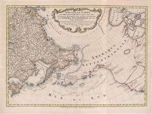
Nouvelle Carte des decouvertes Faites Par Des Vaisseaux Russiens Aux Côtes Inconnues de L'Amerique Septentrionale Avec Les Pais Adiacents.
$1,900.00
Acquire
- Digital Map Information
- Suitable for large format printing
- Full resolution TIFF file
- ICC color profile embedded
- Delivered instantly via download link
A beautiful example of Gerhard Friedrich Müller's important 1766 map of the Pacific Northwest, Alaska, the Bering Strait and Siberia, here in its rare Dutch second edition. Issued after the seminal explorations of Vitus Bering (1733 - 1743) on the Asia side of his namesake strait, but before the voyages of Captain James Cook similarly mapped the American side of the Bering Strait, this map is a smorgasbord of cartographic speculation – such as the exceptionally fine delineation of Friedrich Müller's Peninsula (Alaska / Aleutians). Centered on the Bering Strait, the map covers from Chinese Tartary to the Hudson Bay, and from the high Arctic, south as far as New Mexico, and Honshu (Japan). There is a striking contrast between the well explored Asiatic regions and the starkly bare and highly speculative mapping of America. (more details)