1766 Muller Map of the Bering Strait (Alaska, Siberia, Pacific Northwest)
NouvelleCarteDecouvertes-muller-1766$1,900.00

Title
Nouvelle Carte des decouvertes Faites Par Des Vaisseaux Russiens Aux Côtes Inconnues de L'Amerique Septentrionale Avec Les Pais Adiacents.
1766 (dated) 20 x 26 in (50.8 x 66.04 cm) 1 : 14000000
1766 (dated) 20 x 26 in (50.8 x 66.04 cm) 1 : 14000000
Description
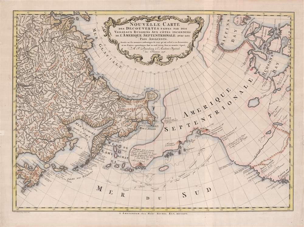
A beautiful example of Gerhard Friedrich Müller's important 1766 map of the Pacific Northwest, Alaska, the Bering Strait and Siberia, here in its rare Dutch second edition. Issued after the seminal explorations of Vitus Bering (1733 - 1743) on the Asia side of his namesake strait, but before the voyages of Captain James Cook similarly mapped the American side of the Bering Strait, this map is a smorgasbord of cartographic speculation – such as the exceptionally fine delineation of Friedrich Müller's Peninsula (Alaska / Aleutians). Centered on the Bering Strait, the map covers from Chinese Tartary to the Hudson Bay, and from the high Arctic, south as far as New Mexico, and Honshu (Japan). There is a striking contrast between the well explored Asiatic regions and the starkly bare and highly speculative mapping of America.
Dezhnyov ultimately proved that there was indeed a nautical route from Russia to East Asia, but at the same time confirmed that it was exceedingly impractical for trade. Nonetheless, his promontory was subsequently embraced by European cartographers who, lacking serious scientific data from the Dezhnyov expedition, surmised the form. The first of these was Dutchman Nicolaes Witsen (1641 - 1717), who prepared a map in 1687 based upon Dezhnyov's records that he discovered on a 1665 trip to Moscow - hence the term Witsen’s Peninsula. Many cartographers followed suit, and some even went so far as to suggest that this landmass may actually be connected to America. Dezhnyov's actual reports were rediscovered by Gerhardt Friedrich Müller who published them in 1758 and incorporated them into his own influential map of the Siberian Arctic.
The Unknown North Pacific
In the middle part of the 18th century there were few paces on Earth as remote or as little known as the American Northwest and the Siberian Northeast in the vicinity of the modern-day Bering Strait. The first major scientific incursion into this region was the 1733 - 1743 Great Northern Expedition led by Vitus Bering and Aleksei Chirikov (1703 - 1748). The expedition was widely discussed in European scientific circles, but Bering and Chirikov's actual discoveries were suppressed by the Russian Academy of Sciences until 1747 when Joseph-Nicholas De L'Isle (1688 - 1768), younger brother of the famous French cartographer Guillaume De L'Isle (1675 - 1726), and who was then working in Russia for the Tzar, fled Russia and published a preliminary interpretation of the Bering-Chirikov discoveries in partnership with Philippe Buache (1700 - 1773). Buache incorporated some of the unpublished cartographic musings of Guillaume De L'Isle, who was by then deceased, to fill in the then largely unknown northeastern parts of America.The St. Petersburg Rebuttal
The St. Petersburg Academy of Sciences was understandably offended by the unofficial leak of knowledge from the Great Northern Expedition and sponsored the German cartographer Gerhard Friedrich Müller to issue an official response map to De L'Isle/Buache. That map, which was published in 1754, and which is referenced in the title above, was the first to contain substantial accurate information with regard to Russian discoveries it the Pacific Northwest and is the basis for much of the cartography seen here, including the Müller's most significant innovation, the so-called Müller Peninsula.The Müller Peninsula
The Müller Peninsula is a large speculative peninsula that bears a vague resemblance to Alaska. It was postulated by Müller based upon his reading of the Bering-Chirikov reports. As shown here on Sayer's map, we can follow the track of the expedition as Bering and Chirikov skirt the Aleutian Islands, sighting land on numerous occasions, before reaching the North American mainland and sighting Mount Saint Elias (Mont de St. Elie). One has no difficulty understanding how, by drawing a line between Bering's sightings of the Aleutian Islands, Müller presumed them connected in the form of a vast Arctic peninsula. Despite the exaggerated westward proportions of Müller's Peninsula, his mapping, as seen here, is significant in that itconfirmed the existence of a body of water between Asia and America, the subject of much dispute during the previous two hundred years. It also showed the Kurile Islands correctly and suggested the outline of Alaska and the Aleutian chain. Though the Russian discoveries had been shown on the De L'Isle map ... published in 1752, … this is the first map to give an approximate picture of what is now Alaska.
Tschuktschi / Witsen's Peninsula
Another feature of extreme interest is the bulbous peninsula identified as Tschuktschi in northeastern Siberia. Earlier versions of this were known as Witsen’s Peninsula. This oddity appears in various forms on numerous maps dating from the late 17th and early 19th century. It is a legacy of Peter the Great's obsession over the search for a Northeast Passage. Around 1648, the Cossack Semen Ivanovich Dezhnyov (1605 - 1673) put together a rough and ready expedition to explore the region. His company consisted of Fedot Alekseyev, traveling with the merchants Andreev and Afstaf'iev (representing the Guselnikov merchant house), who provided their own ship, and Gerasim Ankudinov, an experienced sea captain with his own ship and some 30 men. Dezhnev, along with Mikhail Stadukhin, recruited some 19 men of their own and procured a traditional kocha ship. Including escort vessels, a total seven ships sailed from the mouth the Kolyma River, along the Siberian Arctic, to the Anadyr River north of Kamchatka, and in doing so became the first Europeans to sail through the Bering Strait some 80 years before Vitus Bering. Dezhnyov described rounding a large mountainous promontory identified as Chukchi, Tschuktschi, or Chukotka Peninsula. Of the seven vessels the multiple leaders, only three ships, including Dezhnev’s, survived the passage.Dezhnyov ultimately proved that there was indeed a nautical route from Russia to East Asia, but at the same time confirmed that it was exceedingly impractical for trade. Nonetheless, his promontory was subsequently embraced by European cartographers who, lacking serious scientific data from the Dezhnyov expedition, surmised the form. The first of these was Dutchman Nicolaes Witsen (1641 - 1717), who prepared a map in 1687 based upon Dezhnyov's records that he discovered on a 1665 trip to Moscow - hence the term Witsen’s Peninsula. Many cartographers followed suit, and some even went so far as to suggest that this landmass may actually be connected to America. Dezhnyov's actual reports were rediscovered by Gerhardt Friedrich Müller who published them in 1758 and incorporated them into his own influential map of the Siberian Arctic.
The Pacific Northwest
Beyond the discovery of Mount Saint Elias, much of the Pacific Northwest is notably blank. Along the west coast, the map notes the speculative River of the West, supposedly discovered by Martin D' Aguilar in 1603, the factual Strait of Juan de Fuca falsely attributed to Jean de Fuca (1592), and further north the supposed river entrance discovered of Admiral De Fonte, to which the cartography correctly credits. All of these are present to suggests lingering hope that an inland river route might exist between the Hudson Bay and the Pacific. Nevertheless, between these discoveries and Lake Winnipeg (Ouinipigon) there is little verified content.Publication History and Census
This map was engraved by Leonard Schenk Janszoon and published in Amsterdam by Marc-Michel Rey in 1766, more than 10 years prior to Captain James Cook's historic voyages of discovery which would ultimately shed light on much of this region. Because of the rapid redefining of this region in the second half of the 18th century, this map had a short lifespan and, despite its great historical importance, is scarce to the market. Although widely digitized and reproduced, this map is rare both to the market and in institutional collections in this edition. The only definitive examples of in the OCLC appear in the Bayerische Staatsbibliothek, the William Clements Library, and in the University of British Columbia Library. An essential item for any serious collection focused on the Arctic or the Pacific Northwest.CartographerS
Gerhard Friedrich Müller (Фёдор Ива́нович Ми́ллер; October 29, 1705 - October 22, 1783), also known as Fyodor Ivanovich Miller, was a Russian-German historian, ethnologist and cartographer. He was born in Herford and educated at Leipzig. In 1725, he was among the European scholars invited to St. Petersburg to co-found the Imperial Academy of Sciences. Müller took part in the Academy's Great Northern Expedition (Second Kamchatka Expedition; 1733 - 1743), he and eighteen scientists and artists traveled the area to perform ethnological and botanical studies, as well as collecting data for the creation of maps. Müller's descriptions and categorizations of clothing, religions and rituals of the Siberian ethnic groups earned him the title 'father of ethnography.' He produced an essential map of the arctic and sub-arctic regions of the Pacific in 1754, motivated to counter the geographic frauds perpetrated by Joseph Nicholas De l’Isle (1688 - 1768) and Phillippe Buache (1700 - 1773). He knew both Vitus Bering (1733 - 1743) and Aleksei Chirikov (1703 - 1748), and was as close to his subject matter as any cartographer of his age. More by this mapmaker...
Marc-Michel Rey (May 5, 1720 - June 8, 1780) was a French Huguenot publisher, author, and bookseller active in the Amsterdam in the mid-18th century. Rey was born Geneva, Switzerland. Although he had little formal education, he was apprenticed to the Geneva bookseller Marc-Michel Bosquet from 1733 to 1744. Reaching he maturity, he relocated to Amsterdam, then the capital of the European book trade, where he purchased citizenship and commenced to publishing. Two years later, having quickly establishing himself in the rich Dutch market, he married Elisabeth Bernard, the daughter of a prominent Amsterdam bookseller, Jean Frederic Bernard (1680 - 1744), also of French Huguenot descent. Rey issued few maps, but in the exerted a strong influence on the publishing world. In the words of Utrecht Scholar Wijnand.W. Mijnhardt, 'The Bernard-Rey dynasty was a vital force in the French book trade on Dutch soil for almost 70 years, from 1711 until 1780.' (The Amsterdam booksellers Jean Frederic Bernard (1680-1744) and Marc Michel Rey (1720-1780)). Learn More...
Leonard Schenk Janszoon (February 26, 1696 - June 11, 1767) was a Dutch engraver, the son of Petrus Schenk (Pieter Schenck) the Elder (1660 - 1711). Leonard was bornin Amsterdam and was tough engraving in his father's workshops. Most of Leonard's work focused on geography and architecture, but he also has a significant corpus of portraiture. Leonard engraved several maps and also carried on his father’s relationship with engraving plates for the Amsterdam edition of the Histoire de l'Académie Royale des Sciences. Leonard inherited neither his father's publishing legacy or business, all of which went to his older brothers, but remained a prolific private engraver in the Amsterdam trade through the late 18th century. Learn More...
Condition
Very good. Minor verso repairs. Two sheets joined by publisher. Minor centerfold reinforcements.
References
OCLC 219700947.